Mokotów | |
|---|---|
) | |
) Coat of arms | |
) Location of Mokotów within Warsaw | |
| Coordinates: 52°12′0″N 21°1′1″E / 52.20000°N 21.01694°E | |
| Country | |
| Voivodeship | Masovian |
| County/City | Warsaw |
| Notable landmarks | National Library of Poland, Polish Radio and Television, Pole Mokotowskie, School of Economics, Warsaw University of Life Science, Mokotów Prison |
| Government | |
| • Mayor | Rafał Miastowski [2] |
| Area | |
| • Total | 35.42 km2 (13.68 sq mi) |
| Population (2019) | |
| • Total | 217,683[1] |
| Time zone | UTC+1 (CET) |
| • Summer (DST) | UTC+2 (CEST) |
| Area code(s) | +48 22 |
| Website | mokotow.waw.pl |
Mokotów Polish pronunciation: [mɔˈkɔtuf], is a dzielnica (borough, district) of Warsaw, the capital of Poland. Mokotów is densely populated, and is a seat to many foreign embassies and companies. Only a small part of the district is lightly industrialized (Służewiec Przemysłowy), while the majority is full of parks and green areas (Mokotów Field).
Although the area has been populated at least since the early Middle Ages, it was not until early 1916 when Mokotów was incorporated into Warsaw. The name of the area, first appearing as the village of Mokotowo in documents from the year 1367, has unclear origins. It is hypothesised to have come from the name of a German owner of the village, who called himself Mokoto or Mokot, however no exact reference to such an individual can be found in the historical records. Most of the area was urbanized and redeveloped throughout the 1930s in the style of modernism. The majority of the buildings survived World War II, making it one of the few well-preserved pre-war areas of Warsaw. Mokotów Prison is located within the borough. The residential areas of the district, particularly the neighborhoods of Stary Mokotów and Wyględów, rank among the most expensive in Warsaw.[3]
Subdivision of Mokotów
Administrative units
The following lower-level administrative units (osiedle) are established within Mokotow (they do not cover the whole district).
- Sadyba
- Służewiec Południowy (Southern Sluzewiec)
- Służewiec Fort
Subdivisions
City Information System
Administratively defined in 1996, this district is divided into following areas:[4]
- Stary Mokotów
- Sielce
- Czerniaków
- Siekierki
- Augustówka
- Sadyba
- Stegny
- Wierzbno
- Ksawerów
- Służew
- Służewiec
- Wyględów
Historical
While the following subdivisions have no formal, administrative status, they are recognized in the everyday life.
- Górny Mokotów (Upper Mokotow)
- Stary Mokotów
- Wierzbno
- Ksawerów
- Wyględów
- Królikarnia
- Służew
- Służewiec
- Służewiec Przemysłowy
- Dolny Mokotów (Lower Mokotow)
- Sielce
- Czerniaków
- Siekierki
- Augustówka
- Stegny
- Sadyba
Gallery
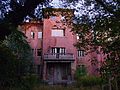
Red Villa on Sułkowskiego Street
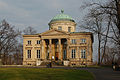
Królikarnia Palace

Sielce Mansion on Cybulskiego Street

Warsaw Metro, Station Wierzbno
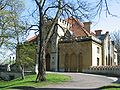
Sztuster Palace
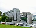
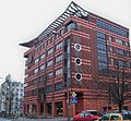
Faculty of Management (University of Warsaw) on Szturmowa Street
Warsaw School of Economics building on Madalińskiego Street

Allotment plots on Augustówka and part of Czerniakowskie Lake
)
)
)
)
)
)
)
)
External links
- Official website

 Mokotów travel guide from Wikivoyage
- ^ "Powierzchnia i ludność w przekroju terytorialnym w 2019 roku. Tabl. 21 Powierzchnia, ludność oraz lokaty według gmi". stat.gov.pl. Główny Urząd Statystyczny. Retrieved 2 September 2020.
- ^ https://bip.warszawa.pl/Menu_podmiotowe/dzielnice/Mokotow/Zarzad_Dzielnicy/Rafal_Miastowski.htm
- ^ https://sonarhome.pl/ceny-mieszkan/warszawa/mokotow/stary-mokotow
- ^ "Archived copy". Archived from the original on 2013-05-09. Retrieved 2013-09-14.