| ||||
|---|---|---|---|---|
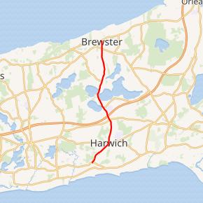 Route 124 highlighted in red | ||||
| Route information | ||||
| Maintained by MassDOT | ||||
| Length | 6.800 mi[1] (10.944 km) | |||
| Existed | 1951–present | |||
| Major junctions | ||||
| South end | ||||
| North end | ||||
| Location | ||||
| Counties | Barnstable | |||
| Highway system | ||||
| ||||
)
Route 124 is a 6.800-mile-long (10.944 km) north–south state highway located in the towns of Harwich and Brewster in the U.S. state of Massachusetts. Its southern terminus is at Route 28 and Route 39 in Harwich and its northern terminus is at Route 6A in Brewster.
Route description
)
Route 124 begins at the intersection of Route 28, overlapping Route 39. It leaves Route 39 next to the First Parish Church in downtown Harwich. After 1.3 miles (2.1 km), the road passes the Mid-Cape Highway at Exit 82 off the Mid-Cape Highway. The road crosses into Brewster just north of a pass between Seymour Pond, Hinckley's Pond, and Long Pond, 1.5 miles (2.41 km) north of the Mid-Cape Highway. After 0.5 miles (0.80 km) the Cape Cod Rail Trail bike path crosses over and follows alongside the road for another 1.5 miles (2.41 km). The road crosses Route 137 after 2 miles (3.22 km). After less than 0.5 miles (0.80 km), the road ends at Route 6A and Harwich Road.[2]
History
Route 124 was formerly designated Route 24, prior to the completion of the initial stretch of the current Route 24 freeway in 1951. When the freeway was given the Route 24 designation, the existing Route 24 was renumbered to 124.
Major intersections
The entire route is in Barnstable County.
| Location | mi[1] | km | Destinations[2] | Notes | |
|---|---|---|---|---|---|
| Harwich | 0.000 | 0.000 | Southern terminus; southern terminus of Route 39 | ||
| 1.673 | 2.692 | Northern terminus of concurrency with Route 39 | |||
| 2.618– 2.851 | 4.213– 4.588 | Exit 82 on US 6 (Mid-Cape Highway); partial cloverleaf interchange | |||
| Brewster | 6.405 | 10.308 | |||
| 6.800 | 10.944 | Northern terminus | |||
1.000 mi = 1.609 km; 1.000 km = 0.621 mi
| |||||
References
- ^ a b MassDOT Planning Division. "Massachusetts Route Log Application". Massachusetts Department of Transportation. Retrieved January 23, 2016.
- ^ a b Google (January 23, 2016). "Massachusetts Route 124" (Map). Google Maps. Google. Retrieved January 23, 2016.