| |||||||||||||
|---|---|---|---|---|---|---|---|---|---|---|---|---|---|
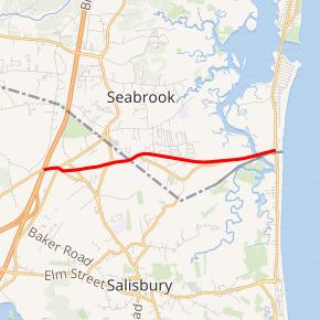 Route 286 highlighted in red | |||||||||||||
| Route information | |||||||||||||
| Maintained by MassDOT and NHDOT | |||||||||||||
| Length | 3.7 mi (6.0 km)
| ||||||||||||
| Major junctions | |||||||||||||
| West end | |||||||||||||
| East end | |||||||||||||
| Location | |||||||||||||
| Counties | MA: Essex, NH: Rockingham | ||||||||||||
| Highway system | |||||||||||||
| |||||||||||||
)
)
Route 286 is a 3.7-mile-long (6.0 km) east–west state highway in Salisbury, Massachusetts and Seabrook, New Hampshire. The route was previously known as Route 86 and was renumbered to avoid a numerical conflict with the designation of a freeway as Interstate 86 in the 1970s. Route 286 is the highest numbered New Hampshire state highway.
Route description
The western terminus of Route 286 is Interstate 95 in Salisbury, Massachusetts, where it is accessed via exit 60 on I-95. Traffic coming from I-95 uses Toll Road, while traffic going to I-95 uses Main Street. The divergence resolves at Pike Street, where Route 286 proceeds eastward, crossing U.S. Route 1 where it becomes Collins Street. After crossing into Seabrook, New Hampshire, Collins Street and Route 286 diverge at an intersection with South Main Street. Route 286 then continues to its eastern terminus with New Hampshire Route 1A (Ocean Boulevard), which runs north–south along the Atlantic shore, approximately 160 feet (49 m) north of the Massachusetts/New Hampshire state line.
The total length of Route 286 is approximately 3.75 miles (6.04 km), of which approximately 2.35 miles (3.78 km) are in New Hampshire and approximately 1.4 miles (2.3 km) are in Massachusetts.
History
)
)
)
Route 286 was previously designated as Route 86 in both Massachusetts and New Hampshire.
Between 1971 and 1984, Massachusetts had an Interstate 86, which ran from Sturbridge, Massachusetts, to Hartford, Connecticut. The construction of I-86 prompted Massachusetts Route 86 to be renumbered to "286" because, according to Massachusetts Highway Department (MassHighway) protocol, a state highway and an Interstate Highway may not share the same number. (The only exception to this rule is Massachusetts Route 295 and I-295, which are on opposite ends of the state.) When Massachusetts renumbered Route 86 to 286, New Hampshire matched the change on its section.
In 1984, plans to connect I-84 along the present day I-384/US 6 corridor from Hartford to Providence were scuttled for environmental reasons. As a result, I-84 was rerouted onto the completed I-86 freeway. The existing section of the old I-84 became I-384. The Massachusetts State Route has kept the 286 number, and by extension the New Hampshire road has as well.
Today, I-86 is the former Southern Tier Expressway/NY Route 17 in New York State as that road is upgraded to Interstate Highway standards. Modern I-86 is unrelated to the I-86 that existed in Massachusetts.
Major intersections
| State | County | Location[2][3] | mi[2][3] | km | Destinations | Notes |
|---|---|---|---|---|---|---|
| Massachusetts | Essex | Salisbury | 0.0 | 0.0 | Western terminus; exit 90 on I-95 (formerly exit 60) | |
| 1.0 | 1.6 | |||||
| 1.4 0.000 | 2.3 0.000 | Massachusetts–New Hampshire state line | ||||
| New Hampshire | Rockingham | Seabrook | 2.356 | 3.792 | Eastern terminus | |
| 1.000 mi = 1.609 km; 1.000 km = 0.621 mi | ||||||
References
- Massachusetts Atlas and Gazetteer (1st ed.). Yarmouth, Maine: DeLorme. 1998. ISBN 089933220X.
- ^ Executive Office of Transportation, Office of Transportation Planning - 2005 Road Inventory Archived 2006-09-27 at the Wayback Machine
- ^ a b c Bureau of Planning & Community Assistance (February 20, 2015). "NH Public Roads". Concord, New Hampshire: New Hampshire Department of Transportation. Retrieved April 7, 2015.
- ^ a b Bureau of Planning & Community Assistance (April 3, 2015). "Nodal Reference 2015, State of New Hampshire". New Hampshire Department of Transportation. Retrieved April 7, 2015.