Wikipedia

Martin Peninsula

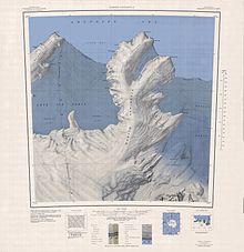
1:250,000 scale topographic map of the Martin Peninsula.

Martin Peninsula (74°20′S 114°30′W / 74.333°S 114.500°W) is a peninsula about 96 km (60) mi long and 32 km (20 mi) wide that is ice-covered except for a few rock outcrops along its margins, located between Getz Ice Shelf and Dotson Ice Shelf on the coast of Marie Byrd Land, Antarctica. The farthest point of the peninsula is Jacobsen Head.

Delineated from aerial photographs taken by USN Operation Highjump in January 1947. Named by US-ACAN after Col. Lawrence Martin, USA (Ret.), American geographer and authority on Antarctic exploration with the Library of Congress; member of US-SCAN, 1943–46.
This article is copied from an article on Wikipedia® - the free encyclopedia created and edited by its online user community. The text was not checked or edited by anyone on our staff. Although the vast majority of Wikipedia® encyclopedia articles provide accurate and timely information, please do not assume the accuracy of any particular article. This article is distributed under the terms of GNU Free Documentation License.

Copyright © 2003-2025 Farlex, Inc Disclaimer
All content on this website, including dictionary, thesaurus, literature, geography, and other reference data is for informational purposes only. This information should not be considered complete, up to date, and is not intended to be used in place of a visit, consultation, or advice of a legal, medical, or any other professional.