Wikipedia

Mark Trail Wilderness

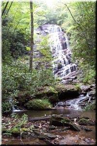
Horsetrough Falls in the Wilderness

The Mark Trail Wilderness was designated in 1991 and currently consists of 16,400 acres (66 km2). It is named in honor of Mark Trail, a daily newspaper comic strip created by the American cartoonist Ed Dodd. The Wilderness is located within the borders of the Chattahoochee National Forest in White, Towns, and Union counties, Georgia. The Wilderness is managed by the United States Forest Service and is part of the National Wilderness Preservation System.

The highest elevation in the Mark Trail Wilderness is the 4,045-foot (1,233 m) peak of Horsetrough Mountain. Fourteen miles (21 km) of the Appalachian Trail cross the Wilderness. The Wilderness features other peaks and Horsetrough Falls on the headwaters of the Chattahoochee River. The Tray Mountain Wilderness is located across State Route 75 to the east.

References

External links

This article is copied from an article on Wikipedia® - the free encyclopedia created and edited by its online user community. The text was not checked or edited by anyone on our staff. Although the vast majority of Wikipedia® encyclopedia articles provide accurate and timely information, please do not assume the accuracy of any particular article. This article is distributed under the terms of GNU Free Documentation License.

Copyright © 2003-2025 Farlex, Inc Disclaimer
All content on this website, including dictionary, thesaurus, literature, geography, and other reference data is for informational purposes only. This information should not be considered complete, up to date, and is not intended to be used in place of a visit, consultation, or advice of a legal, medical, or any other professional.