Wikipedia

Mark (Dender)

Mark
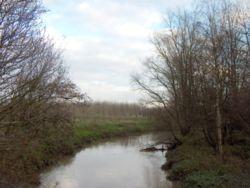
MarkDeux-Acren.JPG
Location
CountryBelgium
Physical characteristics
MouthDender
 • coordinates
50°44′17″N 3°51′49″E / 50.7380°N 3.8636°E
Basin features
ProgressionDenderScheldtNorth Sea

The Mark (Dutch) or Marcq (French) is a river in Belgium, right tributary of the Dender. It rises around 5 kilometres (3 mi) south-west of Enghien, Hainaut, close to the village St-Marcou in the forests of Bois de Ligne en Bois d'Enghien. It passes through the homonymous village Marcq, Enghien, Herne, Tollembeek, Galmaarden, Vollezele, Bever, Moerbeke and Viane. The Mark flows into the Dender in Deux-Acres, between Lessines and Geraardsbergen. The Dender is a tributary of the Scheldt. The Mark is approximately 25 kilometres (16 mi) long.


This article is copied from an article on Wikipedia® - the free encyclopedia created and edited by its online user community. The text was not checked or edited by anyone on our staff. Although the vast majority of Wikipedia® encyclopedia articles provide accurate and timely information, please do not assume the accuracy of any particular article. This article is distributed under the terms of GNU Free Documentation License.

Copyright © 2003-2025 Farlex, Inc Disclaimer
All content on this website, including dictionary, thesaurus, literature, geography, and other reference data is for informational purposes only. This information should not be considered complete, up to date, and is not intended to be used in place of a visit, consultation, or advice of a legal, medical, or any other professional.