| ||||
|---|---|---|---|---|
| Lake Shore Road | ||||
 M-110 highlighted in red | ||||
| Route information | ||||
| Maintained by MDOT | ||||
| Length | 1.715 mi[2] (2.760 km) | |||
| Existed | 1927[1]–2003[3][4] | |||
| Major junctions | ||||
| South end | ||||
| North end | Kott Road north of Parkdale | |||
| Location | ||||
| Counties | Manistee | |||
| Highway system | ||||
| ||||
)
M-110 was the designation of a former state trunkline highway in the US state of Michigan. The highway was a 1.715-mile-long (2.760 km) spur that provided access from US Highway 31 (US 31) to Orchard Beach State Park. The highway was designated in 1927 and lasted until 2003.
Route description
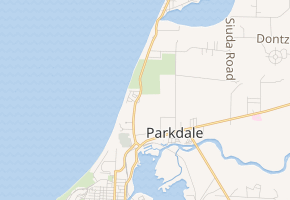
The southern terminus of M-110 was at a junction with US 31 near Parkdale on the northern boundary of the city of Manistee. From there, the trunkline traveled north along Lake Shore Road near Lake Michigan. Along the way, the highway passed through the unincorporated community of Parkdale. The landscape contains fields as the roadway approaches the forest at Orchard Beach State Park. M-110 continues past the park and terminated at an intersection with Kott Road.[5][6]
History
A highway was first designated along Lakeshore Road in 1927 bearing the M-110 designation.[1] In 2003, the Michigan Department of Transportation (MDOT) transferred M-110 to the Manistee County Road Commission.[3][4] In the last traffic surveys before the transfer, MDOT determined that an average of 2,335 vehicles used M-110 on a daily basis in 2002.[7]
Major intersections
The entire highway was in Manistee Township, Manistee County.
| mi[2] | km | Destinations | Notes | ||
|---|---|---|---|---|---|
| 0.000 | 0.000 | ||||
| 1.715 | 2.760 | Kott Road | |||
| 1.000 mi = 1.609 km; 1.000 km = 0.621 mi | |||||
References
- ^ a b Michigan State Highway Department (December 1, 1927). Official Highway Service Map (Map). Scale not given. Lansing: Michigan State Highway Department. Manistee inset. OCLC 12701195, 79754957.
- ^ a b Michigan Department of Transportation & Michigan Center for Shared Solutions and Technology Partnerships (2009). MDOT Physical Reference Finder Application (Map). Michigan Department of Transportation. Retrieved January 9, 2012.
- ^ a b Michigan Department of Transportation (2003). Michigan: Official Department of Transportation Map (Map) (2003–2004 ed.). c. 1:918,720. Lansing: Michigan Department of Transportation. § H8. OCLC 42778335. Retrieved October 17, 2019 – via Michigan History Center.
- ^ a b Michigan Department of Transportation (2004). Michigan: Official Department of Transportation Map (Map) (2003–2004 ed.). c. 1:975,000. Lansing: Michigan Department of Transportation. § H8. OCLC 42778335, 53197160.
- ^ DeLorme (2003). "Manistee County" (Topographic map). Michigan Atlas & Gazetteer (11th ed.). Scale not given. Yarmouth, ME: DeLome. p. 64. ISBN 978-0-89933-335-9.
- ^ Google (January 9, 2012). "Overview Map of Former M-110" (Map). Google Maps. Google. Retrieved January 9, 2012.
- ^ Bureau of Transportation Planning (2008). "Traffic Monitoring Information System". Michigan Department of Transportation. Retrieved January 8, 2012.
External links
- M-110 at Michigan Highways