| ||||
|---|---|---|---|---|
| Pinnebog Road | ||||
 M-105 highlighted in red on a modern map | ||||
| Route information | ||||
| Length | 3.548 mi[3] (5.710 km) | |||
| Existed | 1928[1][2]–1939[4][5] | |||
| Major junctions | ||||
| South end | ||||
| North end | ||||
| Location | ||||
| Counties | Huron | |||
| Highway system | ||||
| ||||
)
M-105 was the designation of a former state trunkline highway in The Thumb region of the US state of Michigan. It served as a connecting route between M-53 in Popple and M-83 (now M-142) near Elkton. The designation was in use in the 1920s and 1930s, and it has not been reused since.
Route description
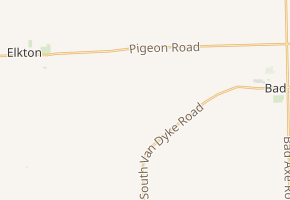
M-105 began at an intersection with M-53 (Van Dyke Road) in the small community of Popple, just before M-53 curved east towards Bad Axe. Known as Pinnebog Road, the trunkline traveled first north and then northwesterly, crossing the Pinnebog River. After intersecting Stein Road, M-105 turned due north for about three miles (4.8 km) through farm country and rural areas before meeting M-83 (Pigeon Road), a few miles east of Elkton. The highway served as a shortcut connector between M-53 and M-83.[3][4]
History
The first appearance of M-105 on maps was in 1928.[1][2] The designation was decommissioned in 1939 when the roadway was transferred back to local control.[4][5] The designation has not been used since.[6]
Major intersections
The entire highway was in Colfax Township, Huron County.
| mi[3] | km | Destinations | Notes | ||
|---|---|---|---|---|---|
| 0.000 | 0.000 | ||||
| 3.548 | 5.710 | ||||
| 1.000 mi = 1.609 km; 1.000 km = 0.621 mi | |||||
References
- ^ a b Michigan State Highway Department (May 1, 1928). Official Highway Service Map (Map). [c. 1:810,000]. Lansing: Michigan State Highway Department. OCLC 12701195, 79754957.
- ^ a b Michigan State Highway Department (October 1, 1928). Official Highway Service Map (Map). [c. 1:810,000]. Lansing: Michigan State Highway Department. OCLC 12701195, 79754957.
- ^ a b c Michigan Department of Transportation & Michigan Center for Shared Solutions and Technology Partnerships (2009). MDOT Physical Reference Finder Application (Map). Michigan Department of Transportation. Retrieved July 6, 2012.
- ^ a b c Michigan State Highway Department & Rand McNally (April 15, 1939). Official Michigan Highway Map (Map) (Summer ed.). [c. 1:850,000]. Lansing: Michigan State Highway Department. § I13. OCLC 12701143.
- ^ a b Michigan State Highway Department & Rand McNally (December 1, 1939). Official Michigan Highway Map (Map) (Winter ed.). [c. 1:850,000]. Lansing: Michigan State Highway Department. § I13. OCLC 12701143. Retrieved October 17, 2019 – via Michigan History Center.
- ^ Michigan Department of Transportation (2012). Pure Michigan: State Transportation Map (Map). c. 1:975,000. Lansing: Michigan Department of Transportation. § I13. OCLC 42778335, 794857350.
External links
- M-105 at Michigan Highways