Luc | |
|---|---|
) The village of Luc, and the chateau | |
) Coat of arms | |
Location of Luc 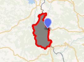 | |
) Luc ) Luc | |
| Coordinates: 44°39′04″N 3°53′30″E / 44.6511°N 3.8917°E | |
| Country | France |
| Region | Occitanie |
| Department | Lozère |
| Arrondissement | Mende |
| Canton | Langogne |
| Government | |
| • Mayor (2014–2020) | Alain Coulon |
| Area 1 | 46.10 km2 (17.80 sq mi) |
| Population (Jan. 2017)[1] | 216 |
| • Density | 4.7/km2 (12/sq mi) |
| Time zone | UTC+01:00 (CET) |
| • Summer (DST) | UTC+02:00 (CEST) |
| INSEE/Postal code | 48086 /48250 |
| Elevation | 925–1,386 m (3,035–4,547 ft) (avg. 971 m or 3,186 ft) |
| 1 French Land Register data, which excludes lakes, ponds, glaciers > 1 km2 (0.386 sq mi or 247 acres) and river estuaries. | |
Luc is a commune in the Lozère department in southern France.
The village of Luc is overlooked by the castle-ruin of Château de Luc. The Robert Louis Stevenson Trail (GR 70), a popular long-distance path, runs past the chateau and through the village.[2]
See also
References
- ^ "Populations légales 2017". INSEE. Retrieved 6 January 2020.
- ^ Castle, Alan (2007). The Robert Louis Stevenson Trail (2nd ed.). Cicerone. pp. 111–115. ISBN 978-1-85284-511-7.
External links
- Luc in Lozere (French)
- Regordane Info - The independent portal for The Regordane Way or St Gilles Trail, which passes through Luc. (in English and French)