Lot 1, Prince Edward Island | |
|---|---|
Township | |
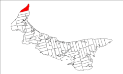
 Map of Prince Edward Island highlighting Lot 1 | |
| Coordinates: 46°57′N 64°5′W / 46.950°N 64.083°W | |
| Country | Canada |
| Province | Prince Edward Island |
| County | Prince County |
| Parish | North Parish |
| Area | |
| • Total | 96.39 km2 (37.22 sq mi) |
| Population (2006) | |
| • Total | 1,881 |
| • Density | 19.5/km2 (51/sq mi) |
| Time zone | UTC-4 (AST) |
| • Summer (DST) | UTC-3 (ADT) |
| Canadian Postal code | C0B |
| Area code(s) | 902 |
| NTS Map | 021I16 |
| GNBC Code | BAEQN |
Lot 1 is a township in Prince County, Prince Edward Island, Canada created during the 1764–1766 survey of Samuel Holland. It is part of North Parish.
Population
- 1,881 (2006 census)
- 1,900 (2001 census)
- 1,936 (1996 census)
Communities
Incorporated municipalities:
Civic address communities:
- Anglo Tignish
- Ascension
- Christopher Cross
- Harper
- Judes Point
- Leoville
- Nail Pond
- Norway
- Palmer Road
- Peterville
- Pleasant View
- Seacow Pond
- Skinners Pond
- St. Felix
- St. Peter and St. Paul
- Tignish
- Tignish Corner
- Tignish Shore
- Waterford
History
The township went through various owners under feudalism when Prince Edward Island was a British colony prior to Canadian Confederation: