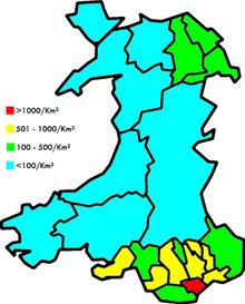
Population in Wales is concentrated in the South Wales Valleys and the northeast; the remainder of Wales is sparsely populated
This is a list of principal areas of Wales showing population, density and area. The figures are estimates for 2019 from the Office for National Statistics.[1]
| District | Population | Population density/km² | Area km² | Style |
|---|---|---|---|---|
| Cardiff | 366,903 | 2,585 | 140 | City and county |
| Swansea | 246,993 | 649 | 378 | City and county |
| Rhondda Cynon Taf | 241,264 | 566 | 424 | County borough |
| Carmarthenshire | 188,771 | 79 | 2,370[2] | County |
| Caerphilly | 181,075 | 653 | 278 | County borough |
| Flintshire | 156,100 | 356 | 438 | County |
| Newport | 154,676 | 805 | 190 | City |
| Bridgend | 147,049 | 578 | 246 | County borough |
| Neath Port Talbot | 143,315 | 324 | 442 | County borough |
| Wrexham | 135,957 | 270 | 498 | County borough |
| Powys | 132,435 | 26 | 5,180[3] | County |
| Vale of Glamorgan | 133,587 | 399 | 335 | County borough |
| Pembrokeshire | 125,818 | 77 | 1,590 | County |
| Gwynedd | 124,560 | 49 | 2,535[4] | County |
| Conwy | 117,203 | 104 | 1,130 | County borough |
| Denbighshire | 95,696 | 114 | 844 | County |
| Monmouthshire | 94,590 | 111 | 850 | County |
| Torfaen | 93,961 | 740 | 126 | County borough |
| Ceredigion | 72,695 | 41 | 1,795 | County |
| Isle of Anglesey | 70,043 | 98 | 714 | County |
| Blaenau Gwent | 69,862 | 641 | 109 | County borough |
| Merthyr Tydfil | 60,326 | 540 | 111 | County borough |
References
- ^ "Population Estimates for UK, England and Wales, Scotland and Northern Ireland, Mid-2019". Office for National Statistics. 6 May 2020. Retrieved 6 May 2020.
- ^ "Carmarthenshire - Population Density (QS102EW)". UKCensusdata.com. Retrieved 2018-06-18.
- ^ "Powys - Population Density (QS102EW)". UKCensusdata.com. Retrieved 2018-06-18.
- ^ "Gwynedd - Population Density (QS102EW)". UKCensusdata.com. Retrieved 2018-06-18.