)
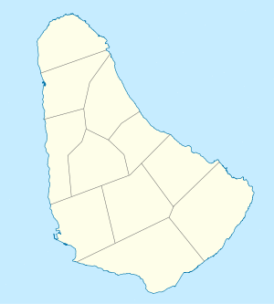
Map of Barbados
This is a list of cities, towns and villages in Barbados. Barbados is a sovereign island country in the Lesser Antilles, in the Americas. It is 34 kilometres (21 miles) in length and up to 23 km (14 mi) in width, covering an area of 432 km2 (167 sq mi). It is situated in the western area of the North Atlantic and 100 km (62 mi) east of the Windward Islands and the Caribbean Sea;[1] Many of the village names in Barbados are based upon the names of plantations.[2] Barbados is divided into 11 parishes.
Christ Church
- Atlantic Shores
- Bannatyne
- Blue Waters
- Boarded Hall
- Briggs
- Callenders
- Cane Vale
- Chancery Lane
- Charnocks
- Clapham
- Hastings
- Maxwell
- Maxwell Hill
- Newton Terrace
- Oistins
- Rockley
- Scarborough
- Seawell
- Saint Lawrence
- Welches
- Woman's Bay
- Worthing
- Wotton
- Yorkshire
Saint Andrew
)
A view looking southeast from Cherry Tree Hill
Saint George
Saint James
)
Highway 1 in Holetown (facing north), close to the public buildings
- Apes Hill
- Appleby
- Carlton
- Holetown
- Lower Carlton
- Mount Standfast
- Oxnards Crescent
- Thorpe
- Upper Carlton
- West Terrace
Saint John
- Bath
- Bowmanston
- Carter
- Cherry Grove
- Kendal
- Saint John
- Saint Marks
- Sherbourne
- Venture
- Messiah Street
Saint Joseph
)
A view of the coast in Bathsheba
- Airy Hill
- Bathsheba
- Bissex
- Blackmans
- Bonwell
- Branchbury
- Buckden House
- Cambridge
- Canefield
- Castle Grant
- Cattlewash
- Chimborazo
- Hackleton's Cliff
- Horse Hill
- Sugar Hill
Saint Lucy
- Alexandra
- Allmans
- Archers
- Babbs
- Bishops
- Blacksage Alley
- Benthams
- Bourbon
- Bromefield
- Cave Hill
- Chance Hall
- Checker Hall
- Church Hill
- Cove Bay
- Crab Hill
- Friendship
- Graveyard
- Lamberts
- Little Bay
- Nesfield
- Pie Corner
- River Bay
- Spring Hall
Saint Michael
)
Bridgetown, Capital of Barbados
)
University Drive at Cave Hill, westbound with the port in the distance
- Bank Hall
- Gay
- Belfield
- Belle
- Bibbys Lane
- Black Rock
- Bridgetown (110,000) – the capital of Barbados
- Brighton
- Brittons Hill
- Bush Hall
- Canewood
- Carrington
- Cave Hill
- Clermont
- Codrington
- Dayrells
- Deacons
- Deacons Farm
- Eagle Hall
- Eden Lodge
- Fairfield
- Friendship
- Friendship Terrace
- Goodland
- Grazettes
- Green Hill
- Haggatt Hall
- Harmony Hall
- Henrys
- Highgate
- Hothersal Turning
- Howells
- Ivy
- Jackmans
- Kew
- Lazarette
- Lodge Hill
- Lower Estate
- Mapp Hill
- Neils
- Prospect
- Rock Dundo
- Rouen
- Spring Garden
- Station Hill
- St Barnabas
- Two Mile Hill
- Upton
- Wanstead
- Warrens
- Waterford
- Whitehall
- Wildey
Saint Peter
- Alleynedale
- Ashburton Grove, The Castle
- Ashton Hall
- Bakers
- Battleys
- Black Bess
- Boscobelle
- The Castle
- Diamond Corner
- Farley Hill
- Fourhill
- French Village
- Gibbes
- Haymans
- Indian Ground
- Mile and a Quarter
- Mangrove Terrace
- Mullins Terrace
- Portland
- Road View
- Rock Hall
- Rose Hill
- Six Mens
- Speightstown (3,600) – the second-largest town centre of Barbados
- Sunbury
- The Whim
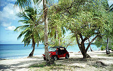
A Mini Moke on the beach at Speightstown, Barbados
)
)
Saint Philip
)
The lighthouse at Ragged Point
- Bayfield
- Bayleys
- Bel Air
- Bentleys
- Blades
- Blades Hill
- Brereton
- Bushy Park
- Carrington
- Caveland
- Church Village
Mangrove
- Four Roads
- Kirtons
- Marchfield
- Saint Martins
- Six Cross Roads
- Ragged Point
- Sunbury
- The Crane
- Three Houses
- Woodbourne
- Workhall
- Rices
- Rock Hall
- Gemswick
- Harlington
- Heddings
- Foul Bay
Saint Thomas
- Allen View
- Applewhaites
- Arch Hall
- Arthurs Seat
- Bagatelle
- Bennetts
- Bloomsbury
- Blowers
- Bridgefield
- Carrington
- Chapman
- Christie
- Welchman Hall
- Cane Garden
- Edge Hill Heights #1
Unsorted
- Husbands
- Mangrove
- Wanstead
See also
- Parishes of Barbados
- List of schools in Barbados
- List of cities by country
- List of towns
References
- ^ Chapter 4 – The Windward Islands and Barbados – U.S. Library of Congress
- ^ "Barbados". Insight Guides. 1998. p. 220. Retrieved 21 June 2016.
- ^ "United States Congressional Serial Set". U.S. Government Printing Office. 1965. p. 375. Retrieved 21 June 2016.
- ^ Howe, G.D.; Marshall, D.D. (2001). The Empowering Impulse: The Nationalist Tradition of Barbados. Canoe Press. p. 156. ISBN 978-976-8125-74-3. Retrieved June 21, 2016.
- ^ Barrow-Giles, C.; Marshall, D.D. (2003). Living at the Borderlines: Issues in Caribbean Sovereignty and Development. Ian Randle Publishers. p. 150. ISBN 978-976-637-148-7. Retrieved June 21, 2016.
- ^ Cameron, S. (2013). Barbados Footprint Focus Guide:. Footprint Focus Guides (in Portuguese). Globe Pequot Press. p. 48. ISBN 978-1-909268-32-6. Retrieved June 21, 2016.
- ^ Brandow, J.C. (1983). Genealogies of Barbados Families: From Caribbeana and the Journal of the Barbados Museum and Historical Society. Genealogical Publishing Company. p. 488. ISBN 978-0-8063-1004-6. Retrieved June 21, 2016.
- ^ Fodor's Barbados, St. Lucia, St. Vincent, the Grenadines & Grenada. Full-color Travel Guide. Fodor's Travel Publications. 2010. p. pt27. ISBN 978-0-307-92803-0. Retrieved June 21, 2016.