Lençóis | |
|---|---|
Municipality | |
) Location in Bahia state | |
) Lençóis Location in Brazil | |
| Coordinates: 12°33′46″S 41°23′24″W / 12.56278°S 41.39000°W | |
| Country | Brazil |
| Region | Northeast |
| State | Bahia |
| Area | |
| • Total | 1,277 km2 (493 sq mi) |
| Population (2020 [1]) | |
| • Total | 11,499 |
| • Density | 9.0/km2 (23/sq mi) |
| Time zone | UTC-03:00 (BRT) |
Lençóis is a municipality in the state of Bahia in Brazil. The population is 11,499 (2020 est.) in an area of 1277 km².[2] The town has a well-preserved colonial atmosphere and is the starting point for treks into Chapada Diamantina. The city is served by Horácio de Mattos Airport.
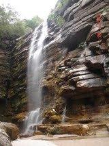
Cachoeira do Mosquito in Lençois - Bahia
References
External links
 Lençóis travel guide from Wikivoyage