Lincoln | |
|---|---|
) LN | |
| Coordinates: 53°15′22″N 0°20′56″W / 53.256°N 0.349°W | |
| Country | United Kingdom |
| Postcode area | LN |
| Postcode area name | Lincoln |
| Post towns | 7 |
| Postcode districts | 13 |
| Postcode sectors | 49 |
| Postcodes (live) | 9,211 |
| Postcodes (total) | 11,935 |
| Statistics as at May 2020[1] | |
The LN postcode area, also known as the Lincoln postcode area,[2] is a group of thirteen postcode districts in England, which are subdivisions of seven post towns. These cover central Lincolnshire, including Lincoln, Alford, Horncastle, Louth, Mablethorpe, Market Rasen and Woodhall Spa.
Coverage
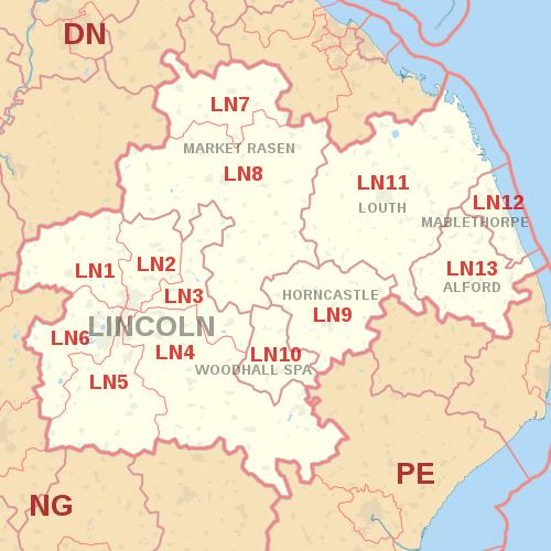
The approximate coverage of the postcode districts:
| Postcode district | Post town | Coverage | Local authority area(s) |
|---|---|---|---|
| LN1 | LINCOLN | Saxilby, Stow, Sturton, City Centre | Lincoln, West Lindsey |
| LN2 | LINCOLN | Nettleham, Ermine & St Giles Estates, Welton, Sudbrooke, Dunholme, Grange de Lings. | Lincoln, West Lindsey |
| LN3 | LINCOLN | Fiskerton, Cherry Willingham, Lincoln, Bardney, Reepham | Lincoln, West Lindsey, North Kesteven, |
| LN4 | LINCOLN | Branston, Canwick, Coningsby, Dunston, Heighington, Nocton, Washingborough, Timberland, Martin, Ashby de la Launde, Scopwick, Holland Fen | Lincoln, North Kesteven, East Lindsey, Boston |
| LN5 | LINCOLN | Waddington | Lincoln, North Kesteven |
| LN6 | LINCOLN | North Hykeham, South Hykeham, Birchwood, Skellingthorpe, Doddington, Whisby, Eagle, North Scarle, Thorpe on the Hill, Witham St Hughs, Swinderby, Norton Disney, Stapleford | Lincoln, North Kesteven |
| LN7 | MARKET RASEN | Nettleton, Caistor | West Lindsey, North Lincolnshire |
| LN8 | MARKET RASEN | Market Rasen | West Lindsey, East Lindsey, North East Lincolnshire |
| LN9 | HORNCASTLE | Horncastle, Tetford, Salmonby, Minting, Belchford, West Ashby, Hemingby, Baumber, Low Toynton, High Toynton, Fulletby, Greetham, Ashby Puerorum, Edlington, Wispington, Mareham on the Hill, Haltham, Winceby, Hameringham, Dalderby, Thornton, Langton, Old Woodhall, Oxcombe, Scrafield | East Lindsey |
| LN10 | WOODHALL SPA | Woodhall Spa, Kirkstead, Roughton, Bucknall, Horsington, Kirkby on Bain, Stixwould | East Lindsey, North Kesteven |
| LN11 | LOUTH | Louth | East Lindsey |
| LN12 | MABLETHORPE | Mablethorpe, Sutton-on-Sea, Theddlethorpe | East Lindsey |
| LN13 | ALFORD | East Lindsey |
Map
See also
References
- ^ "ONS Postcode Directory Version Notes" (ZIP). National Statistics Postcode Products. Office for National Statistics. May 2020. Table 2. Retrieved 19 June 2020. Coordinates from mean of unit postcode points, "Code-Point Open". OS OpenData. Ordnance Survey. February 2012. Retrieved 21 April 2012.
- ^ Royal Mail, Address Management Guide, (2004)