Lærdal kommune | |
|---|---|
Municipality | |
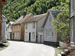
) View of Lærdalsøyri | |
) Coat of arms ) Vestland within Norway | |
) Lærdal within Vestland | |
| Coordinates: 61°03′04″N 07°35′52″E / 61.05111°N 7.59778°E | |
| Country | Norway |
| County | Vestland |
| District | Sogn |
| Established | 1 Jan 1838 |
| Administrative centre | Lærdalsøyri |
| Government | |
| • Mayor (2019) | Audun Mo (Ap) |
| Area | |
| • Total | 1,342.53 km2 (518.35 sq mi) |
| • Land | 1,275.86 km2 (492.61 sq mi) |
| • Water | 66.67 km2 (25.74 sq mi) 5% |
| Area rank | 71 in Norway |
| Population (2020) | |
| • Total | 2,126 |
| • Rank | 274 in Norway |
| • Density | 1.7/km2 (4/sq mi) |
| • Change (10 years) | −3.3% |
| Demonym(s) | Lærdøl[1] |
| Time zone | UTC+01:00 (CET) |
| • Summer (DST) | UTC+02:00 (CEST) |
| ISO 3166 code | NO-4642 |
| Official language form | Nynorsk[2] |
| Website | laerdal |
Lærdal is a municipality in Vestland county, Norway. It is located on the south side of the Sognefjorden in the traditional district of Sogn. The administrative center of the municipality is the village of Lærdalsøyri. The old Filefjell Kongevegen road passes through Lærdal on its way to Valdres and later to Oslo.
The 1,342-square-kilometre (518 sq mi) municipality is the 71st largest by area out of the 356 municipalities in Norway (with over half of this area consisting of mountains). Lærdal is the 274th most populous municipality in Norway with a population of 2,126. The municipality's population density is 1.7 inhabitants per square kilometre (4.4/sq mi) and its population has decreased by 3.3% over the previous 10-year period.[3][4]
The Lærdal river valley is long, running from Hemsedal (Høgeloft mountain) and the Filefjell mountains in the east to the Sognefjorden in the west. About half of the municipal residents live in the main village of Lærdalsøyri; the rest in the small villages in the surrounding valleys such as Borgund, Ljøsne, Tønjum, Erdal, Vindedalen, Frønningen, and Strendene. The Old Lærdalsøyri village has 161 protected buildings. Some of the houses there date back to the mid-18th century. On the night of 18–19 January 2014, a major fire destroyed at least 30 buildings.[5]
General information
)
Lærdal was established as a municipality on 1 January 1838 (see formannskapsdistrikt law). In the 19th century, the name was sometimes spelled Leerdahl or Leirdal. The municipality of 1838 was created to be identical to the Lærdal parish (prestegjeld) that included the sub-parishes (sokn) of Borgund, Tønjum, Hauge, and Aardal. In 1863, the northeastern sub-parish of Aardal (population: 1,791) was separated from Lærdal to form a separate municipality. In 1864, the eastern sub-parish of Borgund (population: 963) was separated from Lærdal to form its own municipality. This left Lærdal with 2,777 residents.
During the 1960s, there were many municipal mergers across Norway due to the work of the Schei Committee. On 1 January 1964, Lærdal (population: 1,755) was merged with the municipality of Borgund (population: 492) and the Muggeteigen, Luggenes, and Bergmål farms (population: 11) along the Sognefjorden from the municipality of Årdal. After the merger, Lærdal had a total of 2,258. On 1 January 1992, the Frønningen area (population: 32) of Leikanger Municipality was transferred to Lærdal municipality.[6][7]
On 1 January 2020, the municipality became part of the newly created Vestland county after Sogn og Fjordane and Hordaland counties were merged.
Name
The Old Norse form of the name was Lærardalr. The first element is the genitive case of the old name of the river Lærr (now the river is called Lærdalselvi) and the last element is dalr which means "valley" or "dale." The meaning of the old river name is unknown.[8]
Coat of arms
The coat of arms was granted on 18 December 1987. It is red with two gold-colored Norse dragon heads. The dragon heads are based on the wooden dragons seen on the gables of the historic Borgund Stave Church in Lærdal.[9]
Churches
The Church of Norway has three parishes (sokn) within the municipality of Lærdal. It is part of the Sogn prosti (deanery) in the Diocese of Bjørgvin.
| Parish (sokn) | Church name | Location of the church | Year built |
|---|---|---|---|
| Borgund | Borgund Church | Borgund | 1868 |
| Borgund Stave Church | c. 1150 | ||
| Hauge | Hauge Church | Lærdalsøyri | 1868 |
| Tønjum | Tønjum Church | Tønjum | 1832 |
Government
All municipalities in Norway, including Lærdal, are responsible for primary education (through 10th grade), outpatient health services, senior citizen services, unemployment and other social services, zoning, economic development, and municipal roads. The municipality is governed by a municipal council of elected representatives, which in turn elect a mayor.[10] The municipality falls under the Sogn og Fjordane District Court and the Gulating Court of Appeal.
Municipal council
The municipal council (Kommunestyre) of Lærdal is made up of 17 representatives that are elected to four year terms. The party breakdown of the council is as follows:
| Party Name (in Nynorsk) | Number of representatives | |
|---|---|---|
| Labour Party (Arbeidarpartiet) | 8 | |
| Conservative Party (Høgre) | 2 | |
| Centre Party (Senterpartiet) | 5 | |
| Socialist Left Party (Sosialistisk Venstreparti) | 2 | |
| Total number of members: | 17 | |
| Party Name (in Nynorsk) | Number of representatives | |
|---|---|---|
| Labour Party (Arbeidarpartiet) | 5 | |
| Conservative Party (Høgre) | 2 | |
| Centre Party (Senterpartiet) | 8 | |
| Socialist Left Party (Sosialistisk Venstreparti) | 1 | |
| Liberal Party (Venstre) | 1 | |
| Total number of members: | 17 | |
| Party Name (in Nynorsk) | Number of representatives | |
|---|---|---|
| Labour Party (Arbeidarpartiet) | 4 | |
| Conservative Party (Høgre) | 3 | |
| Centre Party (Senterpartiet) | 5 | |
| Socialist Left Party (Sosialistisk Venstreparti) | 3 | |
| Liberal Party (Venstre) | 2 | |
| Total number of members: | 17 | |
| Party Name (in Nynorsk) | Number of representatives | |
|---|---|---|
| Labour Party (Arbeidarpartiet) | 7 | |
| Conservative Party (Høgre) | 2 | |
| Centre Party (Senterpartiet) | 5 | |
| Socialist Left Party (Sosialistisk Venstreparti) | 2 | |
| Liberal Party (Venstre) | 1 | |
| Total number of members: | 17 | |
| Party Name (in Nynorsk) | Number of representatives | |
|---|---|---|
| Labour Party (Arbeidarpartiet) | 8 | |
| Progress Party (Framstegspartiet) | 1 | |
| Socialist Left Party (Sosialistisk Venstreparti) | 3 | |
| Joint list of the Conservative Party (Høgre), Christian Democratic Party (Kristeleg Folkeparti), Centre Party (Senterpartiet), and Liberal Party (Venstre) | 5 | |
| Total number of members: | 17 | |
| Party Name (in Nynorsk) | Number of representatives | |
|---|---|---|
| Labour Party (Arbeidarpartiet) | 9 | |
| Socialist Left Party (Sosialistisk Venstreparti) | 2 | |
| Joint list of the Conservative Party (Høgre), Christian Democratic Party (Kristeleg Folkeparti), Centre Party (Senterpartiet), and Liberal Party (Venstre) | 10 | |
| Total number of members: | 21 | |
| Party Name (in Nynorsk) | Number of representatives | |
|---|---|---|
| Labour Party (Arbeidarpartiet) | 10 | |
| Socialist Left Party (Sosialistisk Venstreparti) | 1 | |
| Joint list of the Conservative Party (Høgre), Christian Democratic Party (Kristeleg Folkeparti), Centre Party (Senterpartiet), and Liberal Party (Venstre) | 10 | |
| Total number of members: | 21 | |
| Party Name (in Nynorsk) | Number of representatives | |
|---|---|---|
| Labour Party (Arbeidarpartiet) | 8 | |
| Socialist Left Party (Sosialistisk Venstreparti) | 2 | |
| Joint list of the Conservative Party (Høgre), Christian Democratic Party (Kristeleg Folkeparti), Centre Party (Senterpartiet), and Liberal Party (Venstre) | 11 | |
| Total number of members: | 21 | |
| Party Name (in Nynorsk) | Number of representatives | |
|---|---|---|
| Labour Party (Arbeidarpartiet) | 10 | |
| Conservative Party (Høgre) | 4 | |
| Joint list of the Centre Party (Senterpartiet), Christian Democratic Party (Kristeleg Folkeparti), and Liberal Party (Venstre) | 7 | |
| Total number of members: | 21 | |
| Party Name (in Nynorsk) | Number of representatives | |
|---|---|---|
| Labour Party (Arbeidarpartiet) | 10 | |
| Conservative Party (Høgre) | 3 | |
| Joint list of the Centre Party (Senterpartiet), Christian Democratic Party (Kristeleg Folkeparti), and Liberal Party (Venstre) | 8 | |
| Total number of members: | 21 | |
| Party Name (in Nynorsk) | Number of representatives | |
|---|---|---|
| Labour Party (Arbeidarpartiet) | 9 | |
| Joint list of the Conservative Party (Høgre), Christian Democratic Party (Kristeleg Folkeparti), Liberal People's Party (Liberale Folkepartiet), Centre Party (Senterpartiet), and Liberal Party (Venstre) | 12 | |
| Total number of members: | 21 | |
| Party Name (in Nynorsk) | Number of representatives | |
|---|---|---|
| Labour Party (Arbeidarpartiet) | 10 | |
| Joint list of the Conservative Party (Høgre), Centre Party (Senterpartiet), Liberal Party (Venstre), and New People's Party (Nye Folkepartiet) | 11 | |
| Total number of members: | 21 | |
| Party Name (in Nynorsk) | Number of representatives | |
|---|---|---|
| Labour Party (Arbeidarpartiet) | 12 | |
| Conservative Party (Høgre) | 2 | |
| Centre Party (Senterpartiet) | 6 | |
| Liberal Party (Venstre) | 1 | |
| Total number of members: | 21 | |
| Party Name (in Nynorsk) | Number of representatives | |
|---|---|---|
| Labour Party (Arbeidarpartiet) | 12 | |
| Conservative Party (Høgre) | 1 | |
| Centre Party (Senterpartiet) | 6 | |
| Liberal Party (Venstre) | 2 | |
| Total number of members: | 21 | |
| Party Name (in Nynorsk) | Number of representatives | |
|---|---|---|
| Labour Party (Arbeidarpartiet) | 11 | |
| Conservative Party (Høgre) | 2 | |
| Centre Party (Senterpartiet) | 6 | |
| Liberal Party (Venstre) | 2 | |
| Total number of members: | 21 | |
| Party Name (in Nynorsk) | Number of representatives | |
|---|---|---|
| Labour Party (Arbeidarpartiet) | 9 | |
| Conservative Party (Høgre) | 2 | |
| Centre Party (Senterpartiet) | 7 | |
| Liberal Party (Venstre) | 3 | |
| Total number of members: | 21 | |
| Party Name (in Nynorsk) | Number of representatives | |
|---|---|---|
| Labour Party (Arbeidarpartiet) | 8 | |
| Conservative Party (Høgre) | 1 | |
| Liberal Party (Venstre) | 4 | |
| Local List(s) (Lokale lister) | 8 | |
| Total number of members: | 21 | |
| Party Name (in Nynorsk) | Number of representatives | |
|---|---|---|
| Labour Party (Arbeidarpartiet) | 10 | |
| Liberal Party (Venstre) | 5 | |
| Joint List(s) of Non-Socialist Parties (Borgarlege Felleslister) | 9 | |
| Total number of members: | 24 | |
| Party Name (in Nynorsk) | Number of representatives | |
|---|---|---|
| Labour Party (Arbeidarpartiet) | 9 | |
| Joint List(s) of Non-Socialist Parties (Borgarlege Felleslister) | 15 | |
| Total number of members: | 24 | |
| Party Name (in Nynorsk) | Number of representatives | |
|---|---|---|
| Labour Party (Arbeidarpartiet) | 10 | |
| Liberal Party (Venstre) | 3 | |
| Joint List(s) of Non-Socialist Parties (Borgarlege Felleslister) | 11 | |
| Total number of members: | 24 | |
| Party Name (in Nynorsk) | Number of representatives | |
|---|---|---|
| Labour Party (Arbeidarpartiet) | 7 | |
| Farmers' Party (Bondepartiet) | 9 | |
| Liberal Party (Venstre) | 5 | |
| Local List(s) (Lokale lister) | 3 | |
| Total number of members: | 24 | |
Mayor
The mayor (ordførar) of a municipality in Norway is a representative of the majority party of the municipal council who is elected to lead the council. The mayors of Lærdal (incomplete list):
- 2019–present: Audun Mo (Ap)
- 2011–2019: Jan Geir Solheim (Sp)
- 2007–2011: Arne Sanden (Ap)
- 2003–2007: Knut O. Aarethun (Ap)
Twin towns – Sister cities
Lærdal has sister city agreements with the following places:
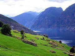
Geography
Lærdal is located southeast of the Sognefjorden and east of the Aurlandsfjorden. The municipality is centered on the Lærdalselvi River with the Filefjell and Hemsedalsfjell mountain ranges on its east. Lærdal is bordered in Vestland county by the municipality of Aurland to the southwest, Sogndal to the northwest, and Årdal to the north. It is also bordered on the east by Vang (Innlandet county) and Hemsedal (Viken county), and in the south by Ål and Hol (both in Viken county).
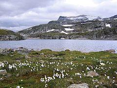
The lakes Eldrevatnet, Juklevatnet, and Øljusjøen are located along the southeastern border, south of the mountain Høgeloft.
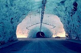
Lærdal tunnel
The Lærdalstunnel was built through the Aurlandsfjell mountains dividing Aurland from Lærdal. It is the world's longest road tunnel (as of 2020) at 24.5 kilometres (15.2 mi). Construction began in 1995 and was completed in 2000.[29]
Lærdalselvi river
.jpg'))
The River Lærdalselvi was traditionally one of the most exclusive salmon and sea trout rivers in Norway. Known by the Norwegian King Harald V as his second Queen, the river has established Lærdal as one of the meccas of salmon and sea trout fly fishing, among others for the unusual fact that the river offers daylight fishing and dry fly fishing for sea trout. The salmon population was drastically depleted after an infestation with the salmon parasite Gyrodactylus salaris in the fall of 1996. After several treatments with aluminium sulfate, there are still problems with the parasite. In fall 2007, a smolt was again found infected by the parasite, and new treatments started in late March 2008. Because of this parasite, the river was closed to angling for the 2008 season.
The river has formed a large delta at Lærdalsøyri, where huge amounts of silt and sand have been deposited by the river. Although the area has been spoiled by some unfortunate landfills it is still a sight worth seeing.
Economy
Lærdal has long traditions in farming, with the lower region of the valley being great for vegetable crops. Because of its dry climate it was one of the first places in Norway to begin the use of artificial irrigation. Despite having an inland climate, the water in the fjord keeps the winters from getting too cold.
The local Western Norway Regional Health Authority hospital provides medical care for Lærdal itself and seven of the surrounding municipalities. The hospital, together with Opplysningen 1881 (directory assistance company), Østfold Energiproduksjon A/S and Norsk Hydro Aluminium Production Facilities in Årdal, are the major employers in Lærdal. The local government and health authority is trying to close this hospital due to cost cutting, which may have negative effects on the area.
Notable people
)
- Peder Hjermann (1754 in Lærdal – 1834) farmer, elected to the Norwegian Constitutional Assembly
- Anders Olson Lysne (1764 - executed 1803) farmer, led the Lærdal farmers' rebellion, 1800 to 1802
- Jan Henrik Nitter Hansen (1801–1879) a businessman and politician, Mayor of Lærdal, 1850's
- Per Lysne (1880 in Lærdal – 1947) a Norwegian-American artist, brought Rosemaling folk art to the USA
- Eivind Blehr (1881 in Lærdal – 1957) politician, Minister in Quisling's government during WWII
- Knut Rumohr (1916 in Lærdal – 2002) a Norwegian painter and printmaker
- Knut O. Aarethun (born 1942 in Lærdalsøyri) politician, Mayor of Lærdal, 2003 to 2007
- Ragnhild Sælthun Fjørtoft (born 1947 in Lærdal) a Norwegian former TV presenter
- Øyvind Hegg-Lunde (born 1982 in Lærdal) musician, plays drums and percussion, raised in Borgund
Photo gallery

Lærdalsøyri
Lærdalsøyri
Old mountain pass from Aurland to Lærdal (above the Lærdalstunnelen)
Old mountain pass from Aurland to Lærdal (above the Lærdalstunnelen)
Lærdal

Lærdal tunnel
Lærdal tunnel cave
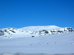
Store Jukleeggi – Mountain in Lærdal
)
)
)
)
)
)
)
References
- ^ "Navn på steder og personer: Innbyggjarnamn" (in Norwegian). Språkrådet.
- ^ "Forskrift om målvedtak i kommunar og fylkeskommunar" (in Norwegian). Lovdata.no.
- ^ Statistisk sentralbyrå (2020). "Table: 06913: Population 1 January and population changes during the calendar year (M)" (in Norwegian).
- ^ Statistisk sentralbyrå (2020). "09280: Area of land and fresh water (km²) (M)" (in Norwegian).
- ^ "Blaze threatens historic wood village in Laerdal Norway". 19 January 2014. Retrieved 19 January 2014.
- ^ Jukvam, Dag (1999). "Historisk oversikt over endringer i kommune- og fylkesinndelingen" (PDF) (in Norwegian). Statistics Norway.
- ^ Natvik, Oddvar (9 February 2005). "Some historical data on the 26 Kommunes". Archived from the original on 13 June 2008. Retrieved 15 June 2008.
- ^ Rygh, Oluf (1919). Norske gaardnavne: Nordre Bergenhus amt (in Norwegian) (12 ed.). Kristiania, Norge: W. C. Fabritius & sønners bogtrikkeri. pp. 60–61.
- ^ "Civic heraldry of Norway - Norske Kommunevåpen". Heraldry of the World. Retrieved 2017-10-22.
- ^ Hansen, Tore, ed. (2016-05-12). "kommunestyre". Store norske leksikon (in Norwegian). Kunnskapsforlaget. Retrieved 2019-04-06.
- ^ "Tall for Norge: Kommunestyrevalg 2019 - Vestland". Valg Direktoratet. Retrieved 2019-10-29.
- ^ a b c d "Table: 04813: Members of the local councils, by party/electoral list at the Municipal Council election (M)" (in Norwegian). Statistics Norway.
- ^ "Tall for Norge: Kommunestyrevalg 2011 - Sogn og Fjordane". Valg Direktoratet. Retrieved 2019-10-29.
- ^ "Kommunestyrevalget 1995" (PDF) (in Norwegian). Oslo-Kongsvinger: Statistisk sentralbyrå. 1996. Retrieved 2020-02-18.
- ^ "Kommunestyrevalget 1991" (PDF) (in Norwegian). Oslo-Kongsvinger: Statistisk sentralbyrå. 1993. Retrieved 2020-02-18.
- ^ "Kommunestyrevalget 1987" (PDF) (in Norwegian). Oslo-Kongsvinger: Statistisk sentralbyrå. 1988. Retrieved 2020-02-18.
- ^ "Kommunestyrevalget 1983" (PDF) (in Norwegian). Oslo-Kongsvinger: Statistisk sentralbyrå. 1984. Retrieved 2020-02-18.
- ^ "Kommunestyrevalget 1979" (PDF) (in Norwegian). Oslo: Statistisk sentralbyrå. 1979. Retrieved 2020-02-18.
- ^ "Kommunevalgene 1975" (PDF) (in Norwegian). Oslo: Statistisk sentralbyrå. 1977. Retrieved 2020-05-01.
- ^ "Kommunevalgene 1972" (PDF) (in Norwegian). Oslo: Statistisk sentralbyrå. 1973. Retrieved 2020-05-01.
- ^ "Kommunevalgene 1967" (PDF) (in Norwegian). Oslo: Statistisk sentralbyrå. 1967. Retrieved 2020-05-01.
- ^ "Kommunevalgene 1963" (PDF) (in Norwegian). Oslo: Statistisk sentralbyrå. 1964. Retrieved 2020-05-01.
- ^ "Kommunevalgene og Ordførervalgene 1959" (PDF) (in Norwegian). Oslo: Statistisk sentralbyrå. 1960. Retrieved 2020-05-01.
- ^ "Kommunevalgene og Ordførervalgene 1955" (PDF) (in Norwegian). Oslo: Statistisk sentralbyrå. 1957. Retrieved 2020-05-01.
- ^ "Kommunevalgene og Ordførervalgene 1951" (PDF) (in Norwegian). Oslo: Statistisk sentralbyrå. 1952. Retrieved 2020-05-01.
- ^ "Kommunevalgene og Ordførervalgene 1947" (PDF) (in Norwegian). Oslo: Statistisk sentralbyrå. 1948. Retrieved 2020-05-01.
- ^ "Kommunevalgene og Ordførervalgene 1945" (PDF) (in Norwegian). Oslo: Statistisk sentralbyrå. 1947. Retrieved 2020-05-01.
- ^ "Kommunevalgene og Ordførervalgene 1937" (PDF) (in Norwegian). Oslo: Statistisk sentralbyrå. 1938. Retrieved 2020-05-01.
- ^ "The world's longest tunnel". Statens vegvesen. Archived from the original on 17 May 2008. Retrieved 18 February 2013.
External links
- Official website: Lærdal Kommune (in Norwegian)
- Municipal fact sheet from Statistics Norway (in Norwegian)
- NRK: Fylkesleksikon – Lærdal Kommune (in Norwegian)