Wikipedia

Kielderhead and Emblehope Moors

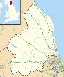
Kielderhead and Emblehope Moors are contiguous areas of moorland in northern Northumberland, England. A section of Kielderhead Moor is part of neighbouring Scotland. The moors are classified as a Biological Site of Special Scientific Interest (SSSI) by the UK government.[1]

Kielderhead and Emblehope Moors
Map showing the location of Kielderhead and Emblehope Moors
LocationNorthumberland, England
OS gridNY745955
Coordinates55°15′11″N 2°24′11″W / 55.253°N 2.403°W

Kielderhead

Kielderhead is 43 square kilometres of upland moorland in northern Northumberland. The moor straddles the English / Scottish border. Kielderhead is owned and managed by the Forestry Commission and is a Site of Special Scientific Interest (SSSI).

Emblehope

Emblehope is 39.5 square kilometres of upland moorland Site of Special Scientific Interest (SSSI) contiguous with Kielderhead. This portion of the moorland is owned and managed by the estate of the Duke of Northumberland.
References

This article is copied from an article on Wikipedia® - the free encyclopedia created and edited by its online user community. The text was not checked or edited by anyone on our staff. Although the vast majority of Wikipedia® encyclopedia articles provide accurate and timely information, please do not assume the accuracy of any particular article. This article is distributed under the terms of GNU Free Documentation License.

Copyright © 2003-2025 Farlex, Inc Disclaimer
All content on this website, including dictionary, thesaurus, literature, geography, and other reference data is for informational purposes only. This information should not be considered complete, up to date, and is not intended to be used in place of a visit, consultation, or advice of a legal, medical, or any other professional.