Keasbey, New Jersey | |
|---|---|
Unincorporated community | |
| Coordinates: 40°31′00″N 74°18′19″W / 40.51667°N 74.30528°W | |
| Country | |
| State | |
| County | Middlesex |
| Township | Woodbridge |
| Named for | Keasbey family |
| Elevation | 36 ft (11 m) |
| ZIP code | 08832 |
| GNIS feature ID | 0877527[1] |
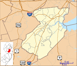
Keasbey is an unincorporated community located within Woodbridge Township in Middlesex County, New Jersey, United States.[2] It is located on the western outskirts of Perth Amboy. Through its proximity to Perth Amboy, and through natural outflow, attraction, and migration, Keasbey is also home to many Hispanic or Latino families.[3]
Keasbey was originally known as Florida Grove[4][5] due to its picnic areas and beaches on the Raritan River. Florida Grove operated until the turn of the nineteenth century when it was abandoned to the clay and brick industries.
The town is named after the Keasbey family, whose home in Morristown is now a museum named Macculloch Hall. One of the brick manufacturers established in Keasbey was a Keasbey family company.
Education
Residents are zoned to the Woodbridge Township School District.
- Grade K-5: Lafayette School 25
- Grade 6-8: Fords Middle School
- Grade 9-12: Depending on location. J.F.K. Memorial High School or Woodbridge High School.
In media
The third wave ska band Catch 22 referenced Keasbey in the title of their album Keasbey Nights in 1998. It was later re-recorded by Streetlight Manifesto in 2006.
Companies
Major employers include:[3]
- FedEx Ground, a division of FedEx, operates a regional hub
- Wakefern, ShopRite's owner and distributor, has its corporate headquarters here[6][7]
See also
- List of neighborhoods in Woodbridge Township, New Jersey
- Neighborhoods in Perth Amboy, New Jersey
- List of neighborhoods in Edison, New Jersey
References
- ^ "Keasbey". Geographic Names Information System. United States Geological Survey. Retrieved 2012-09-28.
- ^ Locality Search, State of New Jersey. Accessed February 9, 2015.
- ^ a b "Keasbey community in Woodbridge has changed over the years".
- ^ Virginia B. Troeger and Robert James McEwen, Woodbridge: New Jersey's Oldest Township (Arcadia Publishing, 2002; ISBN 0738523941), p. 103.
- ^ Gannett, Henry (January 28, 1895). "A Geographic Dictionary of New Jersey". U.S. Government Printing Office – via Google Books.
- ^ "Join the ShopRite Family and Build your Career Opportunities Archived 2011-10-09 at the Wayback Machine." ShopRite. Accessed December 22, 2011.
- ^ "9. VENDOR A/P STATUS INQUIRY USER GUIDELINES Archived 2012-06-08 at the Wayback Machine." Wakefern Food Corporation. Accessed December 22, 2011. "Wakefern Food Corp. 5000 Riverside Drive Keasbey, NJ 08832"


