Kayapa | |
|---|---|
| Municipality of Kayapa | |
) | |
) Seal | |
| Nickname(s): Gateway to the Cordilleras Summer Capital of Nueva Vizcaya | |
) Map of Nueva Vizcaya with Kayapa highlighted | |
OpenStreetMap 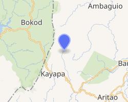 | |
.svg.gif')) Kayapa Location within the Philippines | |
| Coordinates: 16°25′N 120°55′E / 16.42°N 120.92°E | |
| Country | |
| Region | Cagayan Valley (Region II) |
| Province | Nueva Vizcaya |
| District | Lone district |
| Barangays | 30 (see Barangays) |
| Government | |
| • Type | Sangguniang Bayan |
| • Mayor | Elizabeth Balasya |
| • Vice Mayor | Peter L. Bay-an |
| • Representative | Luisa L. Cuaresma |
| • Electorate | 14,889 voters (2019) |
| Area | |
| • Total | 482.90 km2 (186.45 sq mi) |
| Elevation | 1,264 m (4,147 ft) |
| Population (2015 census) [3] | |
| • Total | 23,714 |
| • Density | 49/km2 (130/sq mi) |
| • Households | 5,516 |
| Economy | |
| • Income class | 3rd municipal income class |
| • Poverty incidence | 21.05% (2015)[4] |
| • Revenue | ₱114,520,473.25 (2016) |
| Time zone | UTC+8 (PST) |
| ZIP code | 3708 |
| PSGC | |
| IDD : area code | +63 (0)78 |
| Climate type | tropical rainforest climate |
| Native languages | Ilocano Gaddang Ibaloi I-Wak Kallahan Karao Tagalog |
Kayapa, officially the Municipality of Kayapa (Gaddang: Ili na Kayapa; Ilocano: Ili ti Kayapa; Tagalog: Bayan ng Kayapa), is a 3rd class municipality in the province of Nueva Vizcaya, Philippines. According to the 2015 census, it has a population of 23,714 people. [3]
History
In 1754, Governor General Don Arandia sent Comandante Dovilla, who was based in Pangasinan, to establish a civil government and spread Christianity among the non-Christian Tribes. The mission first saw the Valley of Yapa (Yapa meaning bountiful) which was inhabited by the Allagots, the second descendants of the Bormangi and Owak and the third descendants of the Kalanguya, Ibaloi, Ilo-o and Karao tribes who settled in the fertile valley. When the commandante and his company arrived in the valley of Yapa, the villagers entertained them under a big tree called “Kalabao” which stood in the middle of the valley. It was from these words “Kalabao” and “Yapa” where the present name “Kayapa” was coined. On January 29, 1915, Governor General Francis Burton Harrison signed and issued Executive Order No. 9, transferring all territories of the former Spanish Commandancia of Kayapa, except the area which lies within the Benguet watershed of the Agno River, from the sub-Province of Benguet to the Province of Nueva Vizcaya. On November 11, 1950, President Elpidio Quirino signed Executive Order No. 368 [5] proclaiming the Municipality of Kayapa as a regular town, thus, merging Kayapa and Pingkian into one town as it is today.
Barangays
Kayapa is politically subdivided into 30 barangays.
- Acacia
- Amelong Labeng
- Ansipsip
- Baan
- Babadi
- Balangabang
- Banao
- Binalian
- Besong
- Cabalatan-Alang
- Cabanglasan
- Kayapa Proper East
- Kayapa Proper West
- Mapayao
- Nansiakan
- Pampang (Poblacion)
- Pangawan
- Pinayag
- Pingkian
- San Fabian
- Talecabcab
- Tubongan
- Alang-Salacsac
- Balete
- Buyasyas
- Cabayo
- Castillo Village
- Latbang
- Lawigan
- Tidang Village
Demographics
| Year | Pop. | ±% p.a. |
|---|---|---|
| 1918 | 7,577 | — |
| 1939 | 8,702 | +0.66% |
| 1948 | 5,759 | −4.48% |
| 1960 | 9,298 | +4.07% |
| 1970 | 14,920 | +4.84% |
| 1975 | 20,718 | +6.81% |
| 1980 | 20,491 | −0.22% |
| 1990 | 18,685 | −0.92% |
| 1995 | 19,376 | +0.68% |
| 2000 | 19,193 | −0.20% |
| 2007 | 20,806 | +1.12% |
| 2010 | 21,453 | +1.12% |
| 2015 | 23,714 | +1.93% |
| Source: Philippine Statistics Authority [3] [6] [7][8] | ||
Gallery
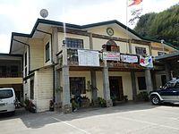
Municipal hall
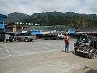
Public market
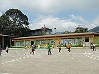
Kayapa Central School
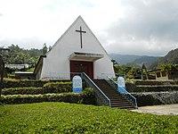
Saint Joseph Parish Church
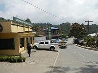
Town proper
)
)
)
)
)
References
- ^ Municipality of Kayapa | (DILG)
- ^ "Province: Nueva Vizcaya". PSGC Interactive. Quezon City, Philippines: Philippine Statistics Authority. Retrieved 12 November 2016.
- ^ a b c Census of Population (2015). "Region II (Cagayan Valley)". Total Population by Province, City, Municipality and Barangay. PSA. Retrieved 20 June 2016.
- ^ "PSA releases the 2015 Municipal and City Level Poverty Estimates". Quezon City, Philippines. Retrieved 1 January 2020.
- ^ "Reorganizing the municipalities and municipal districts in the province of Nueva Vizcaya into ten municipalities, defining their boundaries, and abolishing the municipal districts". Official Gazette of the Republic of the Philippines. Retrieved 2021-01-12.
- ^ Census of Population and Housing (2010). "Region II (Cagayan Valley)". Total Population by Province, City, Municipality and Barangay. NSO. Retrieved 29 June 2016.
- ^ Censuses of Population (1903–2007). "Region II (Cagayan Valley)". Table 1. Population Enumerated in Various Censuses by Province/Highly Urbanized City: 1903 to 2007. NSO.
- ^ "Province of Nueva Vizcaya". Municipality Population Data. Local Water Utilities Administration Research Division. Retrieved 17 December 2016.
External links
 Media related to Kayapa, Nueva Vizcaya at Wikimedia Commons
- Kayapa Profile at PhilAtlas.com
- Philippine Standard Geographic Code
- Philippine Census Information
- Local Governance Performance Management System