Isahaya 諫早市 | |||||||||||
|---|---|---|---|---|---|---|---|---|---|---|---|
) Megane Bridge of Isahaya Park | |||||||||||
) Flag ) Emblem | |||||||||||
) Location of Isahaya in Nagasaki Prefecture | |||||||||||
) Isahaya Location in Japan | |||||||||||
| Coordinates: 32°51′N 130°4′E / 32.850°N 130.067°E | |||||||||||
| Country | Japan | ||||||||||
| Region | Kyushu | ||||||||||
| Prefecture | Nagasaki Prefecture | ||||||||||
| Government | |||||||||||
| • Mayor | Akio Miyamoto (since April 2009) | ||||||||||
| Area | |||||||||||
| • Total | 341.79 km2 (131.97 sq mi) | ||||||||||
| Population (March 1, 2017) | |||||||||||
| • Total | 135,546 | ||||||||||
| • Density | 400/km2 (1,000/sq mi) | ||||||||||
| Time zone | UTC+09:00 (JST) | ||||||||||
| City hall address | 854-8601 | ||||||||||
| Website | www | ||||||||||
| |||||||||||
Isahaya (諫早市, Isahaya-shi) is a city located in Nagasaki Prefecture, Japan. The city was founded on September 1, 1940.
As of July 1, 2018, the city has an estimated population of 135,546 and a population density of 397 persons per km². The total area is 341.79 km2 (131.97 sq mi).
On March 1, 2005, the towns of Tarami, Moriyama, Iimori, Takaki and Konagai (all from Kitatakaki District) were merged to create the new and expanded city of Isahaya. The city was once part of Kitatakaki District, but due to this merger, the district has no more municipalities left and the district was officially dissolved.
History
In July 1957, a severe downpour within Nagasaki caused a large flood in Isahaya, with over 500 casualties and 3500 injuries reported in Isahaya alone.[1]
Geography
Located in the central part of Nagasaki Prefecture. To the north of Isahaya City are mountainous lands of the Takayama mountain range. To the west is the base of the Nagasaki Peninsula and to the south is the base of Shimabara Peninsula. The northeastern part of the city area is surrounded by the three seas of Ōmura Bay in the northwest, Ariake Sea (Isahaya Bay) on the east side and Tachibana Bay on the south side.
Major land reclamation projects have occurred which added plains in the Ariake Sea. The biggest is the Isahaya Bay reclamation project (諫早湾干拓事業) by the Ministry of Agriculture, Forestry and Fisheries that started in 1989. Embankments and sluice gates were built and a total of 35 km2 has been reclaimed as of 2018.
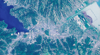
Satellite photograph of Isahaya City (provided by the Geospatial Information Authority of Japan)
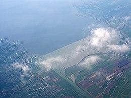
Isahaya Bay (2012)
.jpg'))
)
Surrounding municipalities
Education
Isahaya contains a private university, namely the Nagasaki Wesleyan University. Furthermore, Isahaya have five vocational schools, eight high schools, 16 junior high schools and 28 elementary schools in total.
Transportation
Railways
- JR Kyushu
- Nagasaki Main Line: Konagai - Nagasato - Yue - Oe - Hizen-Nagata - Higashi-Isahaya - Isahaya - Nishi-Isahaya - Kikitsu - Ichinuno
- Ōmura Line: Isahaya
- Shimabara Railway
- Shimabara Railway Line: Isahaya - Hon-Isahaya - Saiwai - Onohonmachi - Kantakunosato - Moriyama - Kamanohana - Isahaya-higashi-kōkōmae
Highways
- Nagasaki Expressway
- Japan national route
- Route 34
- Route 57
- Route 207
- Route 251
Sister cities
 Zhangzhou, China
 Athens, Tennessee, United States
References
- ^ 1957年(昭和32) 7月 諫早豪雨. Japan Meteorological Agency (in Japanese). Retrieved 16 September 2018.
External links
 Media related to Isahaya, Nagasaki at Wikimedia Commons
- Isahaya City official website (in Japanese)