Hidaka 日高市 | |
|---|---|
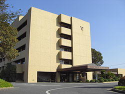
 Hidaka city hall | |
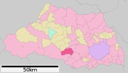
 Location of Hidaka in Saitama Prefecture | |
| Coordinates: 35°54′28.1″N 139°20′20.7″E / 35.907806°N 139.339083°E | |
| Country | Japan |
| Region | Kantō |
| Prefecture | Saitama |
| Government | |
| • Mayor | Teruo Yagasaki (since April 2012) |
| Area | |
| • Total | 47.48 km2 (18.33 sq mi) |
| Population (January 2021) | |
| • Total | 55,294 |
| • Density | 1,200/km2 (3,000/sq mi) |
| Time zone | UTC+9 (Japan Standard Time) |
| - Tree | Osmanthus |
| - Flower | Lespedeza |
| - Bird | Common kingfisher |
| Phone number | 042-989-2111 |
| Address | 1020 Minami-Hirasawa, Hidaka-shi, Saitama-ken 350-1292 |
| Website | Official website |
Hidaka (日高市, Hidaka-shi) is a city located in Saitama Prefecture, Japan. As of 1 January 2021, the city had an estimated population of 55,294 in 24,328 households and a population density of 1200 persons per km².[1] The total area of the city is 47.48 square kilometres (18.33 sq mi).
Geography
Hidaka is located in south-central Saitama Prefecture.
Surrounding municipalities
- Kawagoe
- Sakado
- Hannō
- Tsurugashima
- Sayama
- Moroyama
Climate
Hidaka has a Humid subtropical climate (Köppen Cfa) characterized by warm summers and cool winters with light to no snowfall. The average annual temperature in Hidaka is 14.3 °C. The average annual rainfall is 1427 mm with September as the wettest month. The temperatures are highest on average in August, at around 26.2 °C, and lowest in January, at around 3.4 °C.[2]
Demographics
Per Japanese census data,[3] the population of Hidaka has remained relatively stable over the past 30 years.
| Year | Pop. | ±% |
|---|---|---|
| 1920 | 19,912 | — |
| 1930 | 20,578 | +3.3% |
| 1940 | 12,587 | −38.8% |
| 1950 | 16,108 | +28.0% |
| 1960 | 16,683 | +3.6% |
| 1970 | 21,646 | +29.7% |
| 1980 | 43,219 | +99.7% |
| 1990 | 53,169 | +23.0% |
| 2000 | 53,758 | +1.1% |
| 2010 | 57,502 | +7.0% |
History
The area of modern-day Hidaka was part of ancient Koma District, Musashi Province, mentioned in records dating from 716 AD as a place of resettlement for refugees from the Tang invasion of the Kingdom of Goguryeo on the Korean peninsula in 668 AD. During the Edo period, the area developed as Takahagi-shuku, a post station on the Nikkō Wakiōkan highway linking Edo with Nikkō. The three villages of Komagawa, Koma and Takahagi were established within Koma District with the establishment of the modern municipalities system on April 1, 1889. In 1896 Koma District was abolished, becoming part of Iruma District. On February 11, 1955 Komagawa and Koma merged to create the town of Hidaka. Takahagi joined Hidaka on September 20, 1956. Hidaka was elevated to city status on October 1, 1991.
Government
Hidaka has a mayor-council form of government with a directly elected mayor and a unicameral city council of 16 members. Hidaka contributes one member to the Saitama Prefectural Assembly. In terms of national politics, the city is part of Saitama 9th district of the lower house of the Diet of Japan.
Economy
The economy of Hidaka remains primarily agricultural, with some light manufacturing. A number of housing districts have been built near the train stations, as the city is increasing a bedroom community for Tokyo metropolis to the south.
Education
- Saitama Women's Junior College
- Hidaka has six public elementary schools and six public middle schools operated by the city government, and one public high school operated by the Saitama Prefectural Board of Education. The prefecture also operates one special education school for the handicapped.
Transportation
Railway
![]() JR East – Kawagoe Line
JR East – Kawagoe Line
- Komagawa - Musashi-Takahagi
![]() Seibu Railway - Seibu Ikebukuro Line
Seibu Railway - Seibu Ikebukuro Line
- Koma - Musashi-Yokote
Highway
 National Route 299
 National Route 407
Sister city relations
Local attractions
- Kinchakuda Plateau
- Koma Shrine
References
- ^ "Hidaka city official statistics" (in Japanese). Japan.
- ^ Hidaka climate data
- ^ Hidaka population statistics
- ^ "International Exchange". List of Affiliation Partners within Prefectures. Council of Local Authorities for International Relations (CLAIR). Archived from the original on 4 January 2016. Retrieved 21 November 2015.
External links
- Official Website (in Japanese)


