Hürtgenwald | |
|---|---|
) Coat of arms | |
Location of Hürtgenwald within Düren district 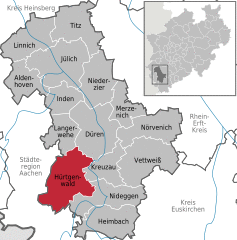 | |
) Hürtgenwald ) Hürtgenwald | |
| Coordinates: 50°42′36″N 06°22′28″E / 50.71000°N 6.37444°E | |
| Country | Germany |
| State | North Rhine-Westphalia |
| Admin. region | Köln |
| District | Düren |
| Subdivisions | 13 |
| Government | |
| • Mayor | Axel Buch (CDU) |
| Area | |
| • Total | 88.05 km2 (34.00 sq mi) |
| Elevation | 300 m (1,000 ft) |
| Population (2019-12-31)[1] | |
| • Total | 8,700 |
| • Density | 99/km2 (260/sq mi) |
| Time zone | UTC+01:00 (CET) |
| • Summer (DST) | UTC+02:00 (CEST) |
| Postal codes | 52393 |
| Dialling codes | 02429 |
| Vehicle registration | DN |
| Website | www.huertgenwald.de |
Hürtgenwald is a municipality in the district of Düren in the federal state of North Rhine-Westphalia, Germany. It is located in the Eifel hills, approx. 15 km south-west of Düren. Much of the area is covered by forest (Hürtgenwald in literal translation means Hürtgen Forest).
)
Hürtgenwald is composed of the villages Bergstein, Brandenberg, Gey, Großhau, Horm, Hürtgen, Kleinhau, Raffelsbrand, Schafberg, Simonskall, Strass, Vossenack and Zerkall (in alphabetical order). Kleinhau with the town hall is not only the administrational center of the community, but has become the commercial center as well (shops and a few supermarkets).
)
In World War II, Hürtgenwald was the theater of what is considered one of the most fierce and tragic battles to date. Two large war graves (one in Hürtgen, one in Vossenack) are places to commemorate those who fell.
Nowadays, the pleasing landscape of forested hills, lakes and rivers attracts a lot of people from nearby densely populated areas, e.g. from the Cologne area and the Ruhr Area, for recreational reasons.
)
See also
- Battle of Hürtgen Forest
- 1944 Hürtgen Forest Museum
References
- ^ "Bevölkerung der Gemeinden Nordrhein-Westfalens am 31. Dezember 2019" (in German). Landesbetrieb Information und Technik NRW. Retrieved 17 June 2020.