Gaya | |
|---|---|
Commune and town | |
| Country | |
| Region | Dosso |
| Department | Gaya |
| Elevation | 594 ft (181 m) |
| Population (2012) | |
| • Total | 63,815 |
| Time zone | UTC+1 (WAT) |
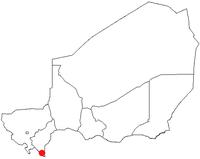
Gaya is a city in the Gaya Department of the Dosso Region of Niger.[1] The city is situated 254 km southeast of the capital, Niamey, is located on the banks of the Niger River,[2] and is near the borders with Benin and Nigeria. Gaya has a population of 28,385 (2001 census). The wettest area in Niger, Gaya averages 800 mm in rainfall a year.
There is a bridge connecting Gaya to the town of Malanville in Benin.[3]

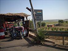
The road border entering Niger from Benin at Gaya.
See also
References
- ^ "Dosso". maplibrary.org. Retrieved 5 February 2007.
- ^ Bullington, J. R (2003). "Letter From Niger". AmericanDiplomacy.com. American Diplomacy Publishers. Retrieved 5 February 2007.
- ^ https://maps.google.com/maps?q=Gaya,%20Niger
External links
