Fort Mitchell | |
|---|---|
) Fort Mitchell Location in Alabama. | |
| Coordinates: 32°20′30″N 85°01′18″W / 32.34167°N 85.02167°W | |
| Country | United States |
| State | Alabama |
| County | Russell |
| Elevation | 354 ft (108 m) |
| Time zone | UTC-6 (Central (CST)) |
| • Summer (DST) | UTC-5 (CDT) |
| Area code(s) | 334 |
| GNIS feature ID | 118523[1] |
Fort Mitchell is an unincorporated community in Russell County, Alabama, United States. The settlement developed around a garrisoned fort intended to provide defense for the area during the Creek War (1813–14).[2]
The community is the home of the Fort Mitchell National Cemetery, established in 1987 for interment of all US veterans.[3]
Landmarks
- Fort Mitchell National Cemetery
- Fort Mitchell Historic Site
Notable people
- James Cantey, Confederate States Army brigadier general
- Samuel Checote, Muskogee Creek, who was the first principal chief of the tribe, then located in Indian Territory, after the Civil War
- John Crowell, first U.S. Representative from Alabama; appointed by President Monroe as the United States agent to the Creek Indians (1821-?)
See also
- Asbury Manual Labor School
Gallery
Below are photographs taken in Fort Mitchell as part of the Historic American Buildings Survey:
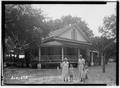
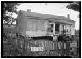
Crowell-Cantey-Alexander House
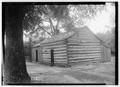
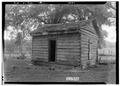
Old slave house, beside Crowell-Cantey-Alexander House
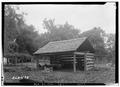
Wood shed, behind Crowell-Cantey-Alexander House
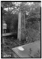
Monument to Col. John Crowell, Sr., at Crowell-Cantey-Alexander House
Old post office
Old Irish gardener house
)
)
)
)
)
)
References
- ^ "Fort Mitchell". Geographic Names Information System. United States Geological Survey.
- ^ "RCH". Rcala.com. Retrieved 2014-06-09.
- ^ National Cemetery Administration. "Fort Mitchell National Cemetery - National Cemetery Administration". Cem.va.gov. Retrieved 2014-06-09.