Wikipedia

Fürstenfeldbruck (district)

Fürstenfeldbruck
District
CountryGermany
StateBavaria
Adm. regionUpper Bavaria
CapitalFürstenfeldbruck
Area
 • Total435 km2 (168 sq mi)
Population
(31 December 2019)[1]
 • Total219,311
 • Density500/km2 (1,300/sq mi)
Time zoneUTC+01:00 (CET)
 • Summer (DST)UTC+02:00 (CEST)
Vehicle registrationFFB
Websitehttp://www.lra-ffb.de

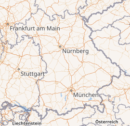
Fürstenfeldbruck is a Landkreis (district) in Bavaria, Germany. It is bounded by (from the east and clockwise) the city of Munich and the districts of Munich, Starnberg, Landsberg, Aichach-Friedberg and Dachau.

History

In medieval times the region was a clerical state ruled by the abbey of Fürstenfeld. When the clerical states of Holy Empire were dissolved in 1803, the territory was annexed by Bavaria. The district of Fürstenfeldbruck was established in 1939.

Geography

The district is occupied by the western Munich metropolitan area. It has the highest population density of all Bavarian districts. More than 90 percent of the population live in the eastern half of the district, which includes the suburbs of Munich.

Coat of arms

Coat of arms
  • The red and white bar is from the family arms of Saint Bernard, who had been the founder of the Cistercian order (Fürstenfeld was a Cistercian monastery)
  • The crown is from the arms of the abbot Alexander Pellhammer
  • The bridge represents the city of Bruck (which was later merged with Fürstenfeld to form the city of Fürstenfeldbruck)

Towns and municipalities
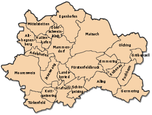
AdelshofenAllingAlthegnenbergEgenhofenEmmeringFürstenfeldbruckGermeringGrafrathGröbenzellHattenhofenJesenwangKottgeiseringLandsberiedMaisachMammendorfMittelstettenMoorenweisOberschweinbachOlchingPuchheimSchöngeisingTürkenfeldCommunities in Fürstenfeldbruck district
Towns Municipalities
  1. Fürstenfeldbruck
  2. Germering
  3. Olching
  4. Puchheim
  1. Adelshofen
  2. Alling
  3. Althegnenberg
  4. Egenhofen
  5. Eichenau
  6. Emmering
  7. Grafrath
  8. Gröbenzell
  9. Hattenhofen
  10. Jesenwang
  1. Kottgeisering
  2. Landsberied
  3. Maisach
  4. Mammendorf
  5. Mittelstetten
  6. Moorenweis
  7. Oberschweinbach
  8. Schöngeising
  9. Türkenfeld

References

  1. ^ "Tabellenblatt "Daten 2", Statistischer Bericht A1200C 202041 Einwohnerzahlen der Gemeinden, Kreise und Regierungsbezirke". Bayerisches Landesamt für Statistik und Datenverarbeitung (in German). July 2020.

External links

This article is copied from an article on Wikipedia® - the free encyclopedia created and edited by its online user community. The text was not checked or edited by anyone on our staff. Although the vast majority of Wikipedia® encyclopedia articles provide accurate and timely information, please do not assume the accuracy of any particular article. This article is distributed under the terms of GNU Free Documentation License.

Copyright © 2003-2025 Farlex, Inc Disclaimer
All content on this website, including dictionary, thesaurus, literature, geography, and other reference data is for informational purposes only. This information should not be considered complete, up to date, and is not intended to be used in place of a visit, consultation, or advice of a legal, medical, or any other professional.