Eps | |
|---|---|
) The church of Eps | |
) Coat of arms | |
Location of Eps 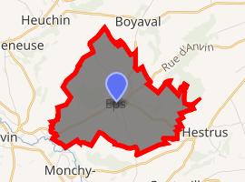 | |
) Eps ) Eps | |
| Coordinates: 50°27′20″N 2°17′48″E / 50.4556°N 2.2967°E | |
| Country | France |
| Region | Hauts-de-France |
| Department | Pas-de-Calais |
| Arrondissement | Arras |
| Canton | Saint-Pol-sur-Ternoise |
| Intercommunality | CC Ternois |
| Government | |
| • Mayor (2008–2014) | Arthur Hermant |
| Area 1 | 6.87 km2 (2.65 sq mi) |
| Population (Jan. 2017)[1] | 250 |
| • Density | 36/km2 (94/sq mi) |
| Time zone | UTC+01:00 (CET) |
| • Summer (DST) | UTC+02:00 (CEST) |
| INSEE/Postal code | 62299 /62134 |
| Elevation | 59–155 m (194–509 ft) (avg. 76 m or 249 ft) |
| 1 French Land Register data, which excludes lakes, ponds, glaciers > 1 km2 (0.386 sq mi or 247 acres) and river estuaries. | |
Eps is a commune in the Pas-de-Calais department in the Hauts-de-France region of France.
Geography
A farming village situated 27 miles (43.5 km) northwest of Arras at the junction of the D70 and D71 roads.
Places of interest
- The church of St. Martin, dating from the sixteenth century.
See also
References
- ^ "Populations légales 2017". INSEE. Retrieved 6 January 2020.
External links
- Eps on the Quid website (in French)