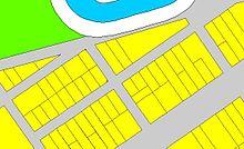
An example of a DCDB file showing properties, road easements and a watercourse
Digital Cadastral DataBase (DCDB) is a computerised map or 'spatial' location showing property boundaries normally in relation to adjoining and other close properties or parcels of land. Commonly used as a basic layer of data used in map based computer programs that gives an outline of the legal boundaries of a property. By using lines to represent an area, features such as rivers and roads can be shown in relation to the property location.
See also
This article is copied from an
article on Wikipedia® - the free encyclopedia created and edited by its online user community. The text was not checked or edited by anyone on our staff. Although the vast majority of Wikipedia® encyclopedia articles provide accurate and timely information, please do not assume the accuracy of any particular article. This article is distributed under the terms of
GNU Free Documentation License.
All content on this website, including dictionary, thesaurus, literature, geography, and other reference data is for informational purposes only. This information should not be considered complete, up to date, and is not intended to be used in place of a visit, consultation, or advice of a legal, medical, or any other professional.
)