| Denbighshire Welsh: Sir Ddinbych | |
|---|---|
Ancient extent of Denbighshire 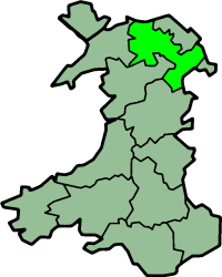 | |
| Area | |
| • 1831 | 386,052 acres (1,562.30 km2) |
| • 1911 | 426,084 acres (1,724.30 km2)[1] |
| • 1961 | 427,978 acres (1,731.97 km2)[1] |
| Population | |
| • 1831 | 83,629[2] |
| • 1911 | 144,783[1] |
| • 1961 | 174,151[1] |
| Density | |
| • 1831 | 0.2/acre |
| • 1911 | 0.3/acre |
| • 1961 | 0.4/acre |
| Chapman code | DEN |
| Government | Denbighshire County Council (1889-1974) |
| • HQ | Denbigh and Ruthin |
Historic Denbighshire (Welsh: Sir Ddinbych) is one of thirteen traditional counties in Wales, a vice-county and a former administrative county, which covers an area in north east Wales. It is a maritime county, bounded to the north by the Irish Sea, to the east by Flintshire, Cheshire and Shropshire, to the south by Montgomeryshire and Merionethshire, and to the west by Caernarfonshire.
Under the Local Government Act 1972, the use of Denbighshire for local government and ceremonial purposes ended on 1 April 1974, with the creation of the new county of Clwyd. A different county of Denbighshire was created on 1 April 1996, for modern local government purposes, covering a substantially different area from the historic county.
History
Denbighshire was created by the Laws in Wales Acts 1535-1542 from areas previously in the Marches. It was formed from Cantrefi taken as follows;
From the Lordship of Denbigh:
- Rhos
- Rhufoniog
- Dyffryn Clwyd
From Powys Fadog:
- Iâl
- Maelor Gymraeg
- Nanheudwy
- Cynllaith
Geography
In the south and west of the county, the mountains of the Clwydian Range rise from 1000 to 2,500 ft (760 m) high. The east is hilly. There is some level ground along the coastal strip. The highest points are Moel Sych and Cader Berwyn at 2,728 feet (831 m). Pistyll-y-Rhaeader is a spectacular 240 feet (73 m) waterfall. The chief rivers are the Clwyd and the Dee. The River Conwy runs north along the western boundary.
The main towns in the county are Rhyl, Abergele, Mochdre, Denbigh, Kinmel Bay, Llangollen, Llanrwst, Wrexham, Colwyn Bay and Ruthin. Villages such as Glan Conwy, Eglwysbach, and Llansannan also came under Denbighshire. The most important industries are agriculture and tourism.
Places of special interest
- Bodnant Gardens, Tal-y-Cafn (grid reference SH7972);
- Chirk Castle (grid reference SJ2638); (now in Wrexham County Borough)
- Denbigh Castle (grid reference SJ0565);
- Pillar of Eliseg (grid reference SJ2044);
- Plas Newydd, Llangollen (grid reference SJ2241);
- Valle Crucis Abbey, Llangollen (grid reference SJ2044).
Municipal reform
An administrative county of Denbighshire was created in 1889 by the Local Government Act 1888. The county was governed by an elected county council, who took over the functions of the Quarter Sessions courts.
The administrative county was subdivided into municipal boroughs and urban and rural districts.
- The boroughs of Denbigh and Ruthin were reformed in 1835 by the Municipal Corporations Act 1835. The county's third borough, Wrexham was incorporated in 1857. Colwyn Bay urban district was incorporated in 1934.
- Three urban districts were formed by the Local Government Act 1894: Abergele and Pensarn (renamed Abergele in 1935), Colwyn Bay and Colwyn (renamed Colwyn Bay in 1926, and incorporated as a borough in 1934) and Llangollen, as successors to urban sanitary districts. in 1897 Llanrwst urban district was formed.
- Eight rural districts were formed (also by the 1894 Act), based on existing rural sanitary districts: Chirk, Llangollen, Llanrwst, Llansillin, Ruthin, St Asaph (Denbigh), Uwchaled and Wrexham.
Two civil parishes: Llaneilian yn Rhos and Llansanffraid Glan Conway were administered as part of Conwy Rural District in the neighbouring county of Caernarfonshire. This area was sometimes called Glan Conway Rural District.
In 1935 the rural districts were reorganised by a County Review Order, and reduced to five in number: Aled, Ceiriog, Hiraethog, Ruthin and Wrexham.
The administrative county was abolished in 1974, with most of its territory becoming part of the new districts of Colwyn, Wrexham Maelor and Glyndŵr in Clwyd. The urban district of Llanrwst and five rural parishes were included in Gwynedd.
See also
- Denbighshire
- List of Lord Lieutenants of Denbighshire
- List of Custodes Rotulorum of Denbighshire
- List of High Sheriffs of Denbighshire
- Denbighshire (UK Parliament constituency)
References
- ^ a b c d Vision of Britain - Denbighshire population (area and density)
- ^ Vision of Britain - 1831 Census