Condé-sur-Ifs | |
|---|---|
) The church in Condé-sur-Ifs | |
Location of Condé-sur-Ifs 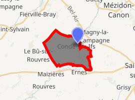 | |
) Condé-sur-Ifs ) Condé-sur-Ifs | |
| Coordinates: 49°02′37″N 0°07′32″W / 49.0436°N 0.1256°W | |
| Country | France |
| Region | Normandy |
| Department | Calvados |
| Arrondissement | Caen |
| Canton | Mézidon-Canon |
| Intercommunality | Vallée d'Auge |
| Government | |
| • Mayor (2008–2014) | Laurent Declerck |
| Area 1 | 12 km2 (5 sq mi) |
| Population (Jan. 2017)[1] | 445 |
| • Density | 37/km2 (96/sq mi) |
| Time zone | UTC+01:00 (CET) |
| • Summer (DST) | UTC+02:00 (CEST) |
| INSEE/Postal code | 14173 /14610 |
| Elevation | 28–81 m (92–266 ft) |
| 1 French Land Register data, which excludes lakes, ponds, glaciers > 1 km2 (0.386 sq mi or 247 acres) and river estuaries. | |
Condé-sur-Ifs is a commune in the Calvados department, in the Normandy region in northwestern France. It is situated on the Ifs river.
Population
| Year | Pop. | ±% |
|---|---|---|
| 1962 | 383 | — |
| 1968 | 361 | −5.7% |
| 1975 | 324 | −10.2% |
| 1982 | 350 | +8.0% |
| 1990 | 368 | +5.1% |
| 1999 | 351 | −4.6% |
| 2008 | 430 | +22.5% |
See also
- Condé (disambiguation)
- Communes of the Calvados department
References
- ^ "Populations légales 2017". INSEE. Retrieved 6 January 2020.