Wikipedia

Combe, Buckfastleigh, Devon

Combe
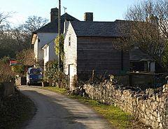
Lower Combe - geograph.org.uk - 1184129.jpg
Lower Combe
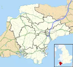
Combe is located in Devon
Combe
Combe
Location within Devon
OS grid referenceSX7068
Civil parish
  • West Buckfastleigh
District
Shire county
Region
CountryEngland
Sovereign stateUnited Kingdom
Post townBUCKFASTLEIGH
Postcode districtTQ11
PoliceDevon and Cornwall
FireDevon and Somerset
AmbulanceSouth Western
UK Parliament

Combe is a small village in the county of Devon, England.[1][2] It lies on the River Mardle about 2 miles north west of the town of Buckfastleigh.

References

  1. ^ Ordnance Survey: Landranger map sheet 202 Torbay & South Dartmoor (Totnes & Salcombe) (Map). Ordnance Survey. 2009. ISBN 9780319232880.
  2. ^ "Ordnance Survey: 1:50,000 Scale Gazetteer" (csv (download)). www.ordnancesurvey.co.uk. Ordnance Survey. 1 January 2016. Retrieved 18 February 2016.

This article is copied from an article on Wikipedia® - the free encyclopedia created and edited by its online user community. The text was not checked or edited by anyone on our staff. Although the vast majority of Wikipedia® encyclopedia articles provide accurate and timely information, please do not assume the accuracy of any particular article. This article is distributed under the terms of GNU Free Documentation License.

Copyright © 2003-2025 Farlex, Inc Disclaimer
All content on this website, including dictionary, thesaurus, literature, geography, and other reference data is for informational purposes only. This information should not be considered complete, up to date, and is not intended to be used in place of a visit, consultation, or advice of a legal, medical, or any other professional.