| Chennai Bypass | |
|---|---|
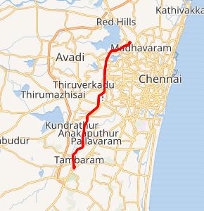 Chennai Bypass in red | |
) | |
| Route information | |
| Part of | |
| Maintained by National Highways Authority of India | |
| Length | 32 km (20 mi) |
| History | Completed in 2010 |
| Major junctions | |
| From | Perungalathur, Chengalpattu district |
| To | puzhal, Chennai district |
| Location | |
| Major cities | Maduravoyal, Ambattur, Porur |
| Highway system | |
| |
The Chennai Bypass is a full-access controlled expressway that interconnects four radial Indian National Highways around Chennai, India covering a distance of 32 km (20 mi) from Perungalathur (near Tambaram) on NH45 to puzhal on NH 5 via Maduravoyal at a cost of ₹ 4.05 billion. Constructed as part of the National Highway Development Project to decongest the city of transiting vehicles, the expressway interconnects NH45, NH4, NH205 and NH5. This expressway now forms a part of the circular transportation corridor.
Phases
Phase I
The first phase is 19 km (12 mi) six-lane fully access controlled carriageway from Perungalathur on the Grand Southern Trunk Road (NH 45) to Maduravoyal which lies on the Chennai–Bangalore NH-4. A 3-tier trumpet interchange has also been constructed at the starting point at Irumbuliyur. It was inaugurated in April 2008. The Road runs through Thiruneermalai, Pammal, Anakaputhur, Tharapakkam, Kovur, Porur, Vanagaram to reach Maduravoyal.
Phase II
The second phase include extending the bypass by 13 km (8.1 mi) from Maduravoyal to Puzhal on the Chennai–Kolkata NH5 and four-laning it. It also includes two interchanges. A clover-leaf grade separator at Maduravoyal Junction and a trumpet interchange at puzhal where the bypass phase II ends.
Elevated Road
A 3.2 kilometres (2.0 mi) elevated six-lane corridor forms the part of the Phase II being executed currently. This elevated road cuts through the Industrial Estate in Ambattur. This corridor ends with a Road over bridge (RoB) crossing the Chennai–Jolarpet railway line. The elevated corridor was completed in June 2009 at a cost of ₹ 1000 million.
Interchanges
- A 3-tier interchange connecting NH45 at Irumbuliyur. This place is where the bypass begins.
- An elevated cloverleaf interchange at Maduravoyal to connect it with the Chennai Port–Maduravoyal Expressway and the proposed Maduravoyal–Sriperumbudur dry port expressway.
- A trumpet interchange at Puzhal[1]
Gallery
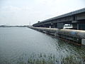
The Porur flyover section of Phase I of the Chennai bypass passing through Porur Lake
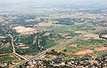
The expressway passes through the outskirts of Chennai
)
)
See also
- Coimbatore bypass
References
- ^ "PIB Foundation stone for Phase II of Chennai Bypass". Archived from the original on 28 September 2007.