| Chapora River | |
|---|---|
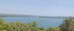
 Chapora River as seen from Chapora Fort | |
| Location | |
| Country | India |
| State | Goa |
| Physical characteristics | |
| Source | |
| • location | Maharashtra, India |
| Mouth | |
• location | Arabian Sea, India |
| Length | 21 km (13 mi) |
| Basin features | |
| Tributaries | |
| • right | Tillari |
Chapora River is a river in northern Goa, India. It runs westward into the Arabian sea at Chapora and demarcates the border between the North Goa talukas of Pernem and Bardez. The river originates at Ramghat in the neighbouring state of Maharashtra[1] enters Goa and flows into the Arabian Sea. Vagator Beach, a tourist destination, is located at the estuary to the south, and to the north is the village of Morjim. There is a bridge across Chapora from Morjim to Siolim. The tributaries of Chapora include Anjuna River and Kalna River.
In the 18th century, the river marked the boundary between Portuguese Goa and India.[2]
References
- ^ Teotonio R. De Souza (1 January 1990). Goa Through the Ages: An economic history. Concept Publishing Company. p. 34. ISBN 978-81-7022-259-0.
- ^ David Abram (2003). Goa. Rough Guides. p. 159. ISBN 978-1-84353-081-7.
See also
- Chapora Fort
- Chapora Beach