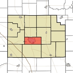
Center Township | |
|---|---|
 Location of Center Township in Clinton County | |
| Coordinates: 40°16′45″N 86°29′52″W / 40.27917°N 86.49778°W | |
| Country | United States |
| State | Indiana |
| County | Clinton |
| Organized | 1872 |
| Government | |
| • Type | Indiana township |
| Area | |
| • Total | 20.62 sq mi (53.4 km2) |
| • Land | 20.62 sq mi (53.4 km2) |
| • Water | 0 sq mi (0 km2) |
| Elevation | 860 ft (262 m) |
| Population (2010) | |
| • Total | 17,245 |
| • Density | 836.4/sq mi (322.9/km2) |
| FIPS code | 18-11260[2] |
| GNIS feature ID | 453174 |
Center Township is one of fourteen townships in Clinton County, Indiana. As of the 2010 census, its population was 17,245 and it contained 6,878 housing units.[3] It contains the city of Frankfort, the county seat.
History
Center Township was created in 1872 from the northern part of Jackson Township; the northern part of Center was later split off to create Union Township in 1889. The first white settler in the township was George Michaels in 1827, followed the next year by John Douglass, Matthew Bunnell and Noah Bunnell. More arrived in 1829, including the three Pence brothers who donated the land upon which the city of Frankfort was built.
As the geographic and business center of the county, numerous railroad where laid through the township and included the Monon, the Vandalia, the Toledo, St. Louis and Western, the Terre Haute, Indianapolis and Eastern, and the Kokomo.[4]
Geography
According to the 2010 census, the township has a total area of 20.62 square miles (53.4 km2), all land.[3]
Cities and towns
Unincorporated towns
- East Park
- Kentwood
- Risse
- Wesley Manor
- Wilshire
- Woodside Park
(This list is based on USGS data and may include former settlements.)
Adjacent townships
- Union Township (north)
- Michigan Township (east)
- Kirklin Township (southeast)
- Jackson Township (south)
- Washington Township (west)
Major highways
Cemeteries
The township contains two cemeteries: Greenlawn Memorial Park and Old South.
References
- "Center Township, Clinton County, Indiana". Geographic Names Information System. United States Geological Survey. Retrieved 2009-09-24.
- United States Census Bureau cartographic boundary files
- ^ "US Board on Geographic Names". United States Geological Survey. 2007-10-25. Retrieved 2008-01-31.
- ^ "U.S. Census website". United States Census Bureau. Retrieved 2008-01-31.
- ^ a b "Population, Housing Units, Area, and Density: 2010 - County -- County Subdivision and Place -- 2010 Census Summary File 1". United States Census. Archived from the original on 2020-02-12. Retrieved 2013-05-10.
- ^ Claybaugh, Joseph (1913). "Center Township". History of Clinton County, Indiana. Indianapolis: A. W. Bowen & Company.