Cairon | |
|---|---|
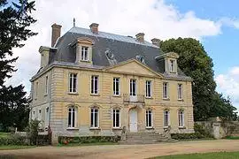
 Chateau | |
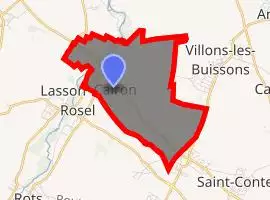
Location of Cairon  | |
| Coordinates: 49°14′28″N 0°26′56″W / 49.2411°N 0.4489°W | |
| Country | France |
| Region | Normandy |
| Department | Calvados |
| Arrondissement | Caen |
| Canton | Bretteville-l'Orgueilleuse |
| Intercommunality | CU Caen la Mer |
| Government | |
| • Mayor (2008–2014) | Claude Yver |
| Area 1 | 5.91 km2 (2.28 sq mi) |
| Population (Jan. 2017)[1] | 1,987 |
| • Density | 340/km2 (870/sq mi) |
| Time zone | UTC+01:00 (CET) |
| • Summer (DST) | UTC+02:00 (CEST) |
| INSEE/Postal code | 14123 /14610 |
| Elevation | 28–72 m (92–236 ft) (avg. 85 m or 279 ft) |
| 1 French Land Register data, which excludes lakes, ponds, glaciers > 1 km2 (0.386 sq mi or 247 acres) and river estuaries. | |
Cairon is a commune in the Calvados department in the Normandy region in northwestern France.
Geography
The commune of Cairon is situated in Normandy, in Calvados, 5 kilometers to the north-west of Caen.
The Mue river and its tributary the Vey flow through Cairon.
Toponymy
Cairon, Karon in 1077 and Cayron in 1231:[2] the toponym was probably formed from the Gallo-Roman Carius by adding the suffix -onis.[3]
History
During the Invasion of Normandy, Cairon was liberated on June 11, 1944, by the 46th Royal Marine Commando.
The demonym (previously gentilic) is Caironnais.
Population
The change in the number of inhabitants is known through a census, taken in the commune since 1793. As of 2006, the recorded population of towns has been published yearly by INSEE. The census is now based on the annual collection of information, successively covering all municipal territories over a period of five years. For towns with fewer than 10,000 inhabitants, a census survey of the entire population is done every five years, while the populations of the years in between are estimated by interpolation or extrapolation. For Cairon, the first comprehensive census within the framework of this new system was carried out in 2008.
In 2015, the commune totaled 1,947 inhabitants, a growth of 20.84% compared to 2010 (Calvados: +1.53%, France outside Mayotte: +2.44%).
| Year | Pop. | ±% |
|---|---|---|
| 1962 | 409 | — |
| 1968 | 480 | +17.4% |
| 1975 | 664 | +38.3% |
| 1982 | 809 | +21.8% |
| 1990 | 1,098 | +35.7% |
| 1999 | 1,585 | +44.4% |
| 2008 | 1,571 | −0.9% |
See also
References
- ^ "Populations légales 2017". INSEE. Retrieved 6 January 2020.
- ^ Albert Dauzat and Charles Rostaing, Dictionnaire étymologique des noms de lieux en France, Paris, Larousse, 1963
- ^ René Lepelley, Dictionnaire étymologique des noms de communes de Normandie, Condé-sur-Noireau, Éd. Charles Corlet, 1996 (ISBN 2-95480-455-4, notice BnFno FRBNF36174448), p. 83
.svg.gif)

