Wikipedia

Cache River State Natural Area

Also found in: Encyclopedia.
Cache River State Natural Area
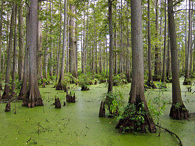
Heron Pond in Cache River State Natural Area.jpg
Taxodium distichum in Heron Pond
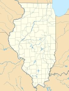
Map showing the location of Cache River State Natural Area
Map of the U.S. state of Illinois showing the location of Cache River State Natural Area
LocationJohnson County, Illinois, USA
Nearest cityBelknap, Illinois
Coordinates37°21′44″N 88°57′20″W / 37.36222°N 88.95556°W
Area14,314 acres (5,793 ha)
Established1970
Governing bodyIllinois Department of Natural Resources

Cache River State Natural Area is an Illinois state park centered on the Cache River (Illinois) of 14,314 acres (5,793 ha) in Johnson County, Illinois, United States.

References

  • "Cache River State Natural Area". Illinois Department of Natural Resources. Archived from the original on 2007-06-07. Retrieved 2018-07-06.
  • USGS. "Cache River State Natural Area, USGS Karnak (IL) Quad". TopoQuest. Retrieved 2008-07-05.

This article is copied from an article on Wikipedia® - the free encyclopedia created and edited by its online user community. The text was not checked or edited by anyone on our staff. Although the vast majority of Wikipedia® encyclopedia articles provide accurate and timely information, please do not assume the accuracy of any particular article. This article is distributed under the terms of GNU Free Documentation License.

Copyright © 2003-2025 Farlex, Inc Disclaimer
All content on this website, including dictionary, thesaurus, literature, geography, and other reference data is for informational purposes only. This information should not be considered complete, up to date, and is not intended to be used in place of a visit, consultation, or advice of a legal, medical, or any other professional.