Brémes | |
|---|---|
_église_(01).JPG')) The church of Brêmes | |
) Coat of arms | |
Location of Brémes 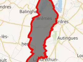 | |
) Brémes ) Brémes | |
| Coordinates: 50°51′20″N 1°58′14″E / 50.8556°N 1.9706°E | |
| Country | France |
| Region | Hauts-de-France |
| Department | Pas-de-Calais |
| Arrondissement | Calais |
| Canton | Calais-2 |
| Intercommunality | CC Pays d'Opale |
| Government | |
| • Mayor (2008–2014) | Thierry Poussière |
| Area 1 | 7.25 km2 (2.80 sq mi) |
| Population (Jan. 2017)[1] | 1,290 |
| • Density | 180/km2 (460/sq mi) |
| Time zone | UTC+01:00 (CET) |
| • Summer (DST) | UTC+02:00 (CEST) |
| INSEE/Postal code | 62174 /62610 |
| Elevation | 3–76 m (9.8–249.3 ft) (avg. 60 m or 200 ft) |
| 1 French Land Register data, which excludes lakes, ponds, glaciers > 1 km2 (0.386 sq mi or 247 acres) and river estuaries. | |
Brémes is a commune in the Pas-de-Calais department in the Hauts-de-France region in northern France.
Geography
A village situated 10 miles (16 km) south of Calais, on the D213 road. Surrounded by water, including the lake of Brêmes.
Population
| Year | Pop. | ±% |
|---|---|---|
| 1962 | 771 | — |
| 1968 | 855 | +10.9% |
| 1975 | 873 | +2.1% |
| 1982 | 1,067 | +22.2% |
| 1990 | 1,264 | +18.5% |
| 1999 | 1,315 | +4.0% |
| 2009 | 1,299 | −1.2% |
Sights
- The church of the St. Martin, dating from the late 19th century.
- The ruins of a watermill.
See also
References
- ^ "Populations légales 2017". INSEE. Retrieved 6 January 2020.
External links
- Official website of the commune (in French)