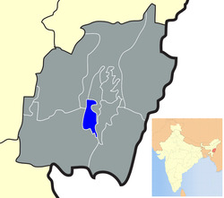
Bishnupur district Bishenpur | |
|---|---|
District | |
 Location of Bishnupur district in Manipur | |
| Coordinates: 24°38′N 93°46′E / 24.633°N 93.767°E | |
| Country | |
| State | Manipur |
| Headquarters | Bishnupur |
| Area | |
| • Total | 496 km2 (192 sq mi) |
| Population (2011) | |
| • Total | 237,399 |
| • Density | 21.83/km2 (56.5/sq mi) |
| Languages | |
| • Official | Meiteilon (Manipuri) |
| Time zone | UTC+5:30 (IST) |
| ISO 3166 code | IN-MN-BI |
| Vehicle registration | MN |
| Website | bishnupur |
Bishnupur district (Pron:/ˌbɪʃnʊˈpʊə/) is the district of Manipur state in northeastern India.
Origin of name
Its name is derived from a Vishnu temple located at Lamangdong.[1]
Geography
Bishnupur town is the administrative headquarters of the district. Other major towns in this district are: Nambol, Moirang, Ningthoukhong, and Kumbi. Major village in this district are Nachou, Ngaikhong Khullen, Toubul, and Khoijuman Khullen.
Demographics
According to the 2011 census Bishnupur district has a population of 237,399,[2] roughly equal to the nation of Vanuatu.[3] This gives it a ranking of 583rd in India (out of a total of 640).[2] The district has a population density of 485 inhabitants per square kilometre (1,260/sq mi) .[2] Its population growth rate over the decade 2001-2011 was 15.36%.[2] Bishnupur has a sex ratio of 1000 females for every 1000 males,[2] and a literacy rate of 76.35%.[2]
Languages
Primary language spoken is Meiteilon. Other minority languages spoken includes Rongmei, Nepali, Bengali, Hindi and Thadou.
Flora and fauna
In 1977 Bishnupur district became home to Keibul Lamjao National Park, which has an area of 40 km2 (15.4 sq mi).[4]
Administrative divisions
The district is divided into 3 sub-divisions:
References
- ^ "History of Bishnupur | Bishnupur District, Government of Manipur | India". Retrieved 24 February 2020.
- ^ a b c d e f "District Census 2011". Census2011.co.in. 2011. Retrieved 30 September 2011.
- ^ US Directorate of Intelligence. "Country Comparison:Population". Retrieved 1 October 2011.
Vanuatu 224,564 July 2011 est.
- ^ Indian Ministry of Forests and Environment. "Protected areas: Manipur". Archived from the original on 9 October 2011. Retrieved 25 September 2011.
External links
- Bishnupur district website
 Bishnupur district travel guide from Wikivoyage