Wikipedia

Banggai Island

Banggai Island
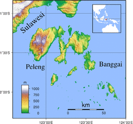
Banggai Islands Topography.png
Geography
LocationSouth East Asia
Coordinates1°37′S 123°34′E / 1.617°S 123.567°E
ArchipelagoBanggai Islands
Area268 km2 (103 sq mi)
Administration
Indonesia
ProvinceCentral Sulawesi
Demographics
Population37,155 (2010 Census)
Pop. density138.6/km2 (359/sq mi)

Banggai Island is the second largest of the Banggai Islands, an archipelago located at the far eastern end of Central Sulawesi, Indonesia. The largest island is Peleng, smaller islands of the group are Bowokan, Labobo, Kebongan, Kotudan, Tropettenando, Timpau, Salue Besar, Salue Kecil, Masepe, and Bangkulu.

Banggai Island has an area of 268 square kilometres (103 sq mi) and a population of 37,155 (2010 census).

References


This article is copied from an article on Wikipedia® - the free encyclopedia created and edited by its online user community. The text was not checked or edited by anyone on our staff. Although the vast majority of Wikipedia® encyclopedia articles provide accurate and timely information, please do not assume the accuracy of any particular article. This article is distributed under the terms of GNU Free Documentation License.

Copyright © 2003-2025 Farlex, Inc Disclaimer
All content on this website, including dictionary, thesaurus, literature, geography, and other reference data is for informational purposes only. This information should not be considered complete, up to date, and is not intended to be used in place of a visit, consultation, or advice of a legal, medical, or any other professional.