Balete | |
|---|---|
| Municipality of Balete | |
) | |
) Seal | |
) Map of Batangas with Balete highlighted | |
OpenStreetMap 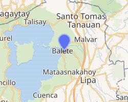 | |
.svg.gif')) Balete Location within the Philippines | |
| Coordinates: 14°01′N 121°06′E / 14.02°N 121.1°E | |
| Country | |
| Region | Calabarzon (Region IV-A) |
| Province | Batangas |
| District | 3rd District |
| Founded | June 21, 1969 [1] |
| Barangays | 13 (see Barangays) |
| Government | |
| • Type | Sangguniang Bayan |
| • Mayor | Wilson V. Maralit |
| • Vice Mayor | Alvin T. Payo |
| • Representative | Ma. Theresa V. Collantes |
| • Electorate | 14,181 voters (2019) |
| Area | |
| • Total | 25.00 km2 (9.65 sq mi) |
| Elevation | 187 m (614 ft) |
| Population (2015 census) [4] | |
| • Total | 22,661 |
| • Density | 910/km2 (2,300/sq mi) |
| • Households | 4,580 |
| Economy | |
| • Income class | 5th municipal income class |
| • Poverty incidence | 7.72% (2015)[5] |
| • Revenue | ₱58,242,852.49 (2016) |
| Time zone | UTC+8 (PST) |
| ZIP code | 4219 |
| PSGC | |
| IDD : area code | +63 (0)43 |
| Climate type | tropical monsoon climate |
| Native languages | Tagalog |
Balete, officially the Municipality of Balete (Tagalog: Bayan ng Balete), is a 5th class municipality in the province of Batangas, Philippines. According to the 2015 census, it has a population of 22,661 people. [4]
Balete is well known for its location on Taal Lake, providing a panoramic view of the Taal Volcano. The pilgrimage site Marian Orchard is located in Barangay Malabanan.
On February 13, 2008, incumbent Mayor David Pamplona was assassinated in Barangay Bulihan, Malvar.[6]
Geography
According to the Philippine Statistics Authority, the municipality has a land area of 25.00 square kilometres (9.65 sq mi) [3] constituting 0.80% of the 3,119.75-square-kilometre- (1,204.54 sq mi) total area of Batangas.
Barangays
Balete is politically subdivided into 13 barangays.[7]
| PSGC | Barangay | Population | ±% p.a. | |||
|---|---|---|---|---|---|---|
| 2015 [4] | 2010 [8] | |||||
| 041004001 | Alangilan | 6.3% | 1,428 | 1,296 | 1.86% | |
| 041004002 | Calawit | 4.5% | 1,028 | 809 | 4.67% | |
| 041004003 | Looc | 9.3% | 2,098 | 2,005 | 0.87% | |
| 041004004 | Magapi | 9.4% | 2,133 | 1,947 | 1.75% | |
| 041004005 | Makina | 7.8% | 1,757 | 1,519 | 2.81% | |
| 041004006 | Malabanan | 20.5% | 4,637 | 4,119 | 2.28% | |
| 041004007 | Paligawan | 9.0% | 2,047 | 1,802 | 2.46% | |
| 041004008 | Palsara | 6.1% | 1,391 | 1,381 | 0.14% | |
| 041004009 | Poblacion | 11.4% | 2,573 | 2,405 | 1.29% | |
| 041004010 | Sala | 7.7% | 1,753 | 1,429 | 3.97% | |
| 041004011 | Sampalocan | 4.8% | 1,086 | 1,003 | 1.53% | |
| 041004012 | Solis | 7.6% | 1,712 | 1,634 | 0.89% | |
| 041004013 | San Sebastian | 4.5% | 1,018 | 1,865 | −10.89% | |
| Total | 22,661 | 20,214 | 2.20% | |||
Climate
| Climate data for Balete, Batangas | |||||||||||||
|---|---|---|---|---|---|---|---|---|---|---|---|---|---|
| Month | Jan | Feb | Mar | Apr | May | Jun | Jul | Aug | Sep | Oct | Nov | Dec | Year |
| Average high °C (°F) | 29 (84) | 30 (86) | 31 (88) | 33 (91) | 32 (90) | 30 (86) | 29 (84) | 29 (84) | 29 (84) | 29 (84) | 29 (84) | 29 (84) | 30 (86) |
| Average low °C (°F) | 20 (68) | 20 (68) | 21 (70) | 22 (72) | 24 (75) | 24 (75) | 24 (75) | 24 (75) | 24 (75) | 23 (73) | 22 (72) | 21 (70) | 22 (72) |
| Average precipitation mm (inches) | 11 (0.4) | 13 (0.5) | 14 (0.6) | 32 (1.3) | 101 (4.0) | 142 (5.6) | 208 (8.2) | 187 (7.4) | 175 (6.9) | 131 (5.2) | 68 (2.7) | 39 (1.5) | 1,121 (44.3) |
| Average rainy days | 5.2 | 5.0 | 7.4 | 11.5 | 19.8 | 23.5 | 27.0 | 25.9 | 25.2 | 23.2 | 15.5 | 8.3 | 197.5 |
| Source: Meteoblue [9] (Use with caution: this is modeled/calculated data, not measured locally.) | |||||||||||||
Demographics
|
| |||||||||||||||||||||||||||||||||
| Source: Philippine Statistics Authority [4] [8] [10][11] | ||||||||||||||||||||||||||||||||||
In the 2015 census, Balete had a population of 22,661. [4] The population density was 910 inhabitants per square kilometre (2,400/sq mi).
Gallery
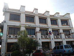
Municipal hall
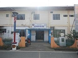
Police station
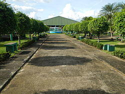
Municipal park
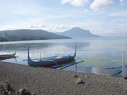
Fishing boats on the shore of Taal Lake
Marian Orchard
)
)
)
)
)
References
- ^ http://www.thecorpusjuris.com/legislative/republic-acts/ra-no-5659.php
- ^ Municipality of Balete | (DILG)
- ^ a b "Province: Batangas". PSGC Interactive. Quezon City, Philippines: Philippine Statistics Authority. Retrieved 12 November 2016.
- ^ a b c d e Census of Population (2015). "Region IV-A (Calabarzon)". Total Population by Province, City, Municipality and Barangay. PSA. Retrieved 20 June 2016.
- ^ "PSA releases the 2015 Municipal and City Level Poverty Estimates". Quezon City, Philippines. Retrieved 1 January 2020.
- ^ Arnell Ozaeta; Ed Amoroso (February 14, 2008). "Batangas Mayor killed in ambush". The Philippine Star. Retrieved August 23, 2012.
- ^ "Municipal: Balete, Batangas". PSGC Interactive. Quezon City, Philippines: Philippine Statistics Authority. Retrieved 8 January 2016.
- ^ a b Census of Population and Housing (2010). "Region IV-A (Calabarzon)". Total Population by Province, City, Municipality and Barangay. NSO. Retrieved 29 June 2016.
- ^ "Balete: Average Temperatures and Rainfall". Meteoblue. Retrieved 5 May 2020.
- ^ Censuses of Population (1903–2007). "Region IV-A (Calabarzon)". Table 1. Population Enumerated in Various Censuses by Province/Highly Urbanized City: 1903 to 2007. NSO.
- ^ "Province of Batangas". Municipality Population Data. Local Water Utilities Administration Research Division. Retrieved 17 December 2016.
External links
![]() Media related to Balete, Batangas at Wikimedia Commons
Media related to Balete, Batangas at Wikimedia Commons