Areti Αρετή | |
|---|---|
| Coordinates: 37°58′N 21°18′E / 37.967°N 21.300°E | |
| Country | Greece |
| Administrative region | West Greece |
| Regional unit | Elis |
| Municipality | Andravida-Kyllini |
| Municipal unit | Lechaina |
| Elevation | 5 m (16 ft) |
| Community | |
| • Population | 220 (2011) |
| Time zone | UTC+2 (EET) |
| • Summer (DST) | UTC+3 (EEST) |
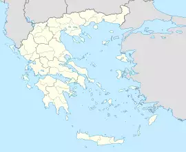
Areti (Greek: Αρετή) is a community in the municipal unit of Lechaina, Elis, Greece. It is situated in a flat, rural area, south of the Kotychi lagoon. It is 1 km west of Kourtesi and 5 km northeast of Lechaina. The Greek National Road 9/E55 (Patras - Pyrgos) and the railway Patras - Pyrgos pass south of the village. The site of ancient Myrsinus (known as Myrtuntium in later times) is located near Areti.
Population
| Year | Population |
|---|---|
| 1981 | 527 |
| 1991 | 447 |
| 2001 | 499 |
| 2011 | 220 |
See also
- List of settlements in Elis
External links
See also
- Arete
- List of settlements in Elis
References
- ^ a b "Απογραφή Πληθυσμού - Κατοικιών 2011. ΜΟΝΙΜΟΣ Πληθυσμός" (in Greek). Hellenic Statistical Authority.
