Aguaí | |
|---|---|
Municipality | |
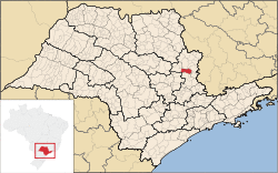
 Location in São Paulo state | |
| Coordinates: 22°3′37″S 46°58′25″W / 22.06028°S 46.97361°W | |
| Country | Brazil |
| Region | Southeast |
| State | São Paulo |
| Area | |
| • Total | 475 km2 (183 sq mi) |
| Elevation | 653 m (2,142 ft) |
| Population (2020 [1]) | |
| • Total | 36,648 |
| • Density | 77/km2 (200/sq mi) |
| Time zone | UTC-03:00 (BRT) |
| • Summer (DST) | UTC-02:00 (BRST) |
Aguaí is a Brazilian municipality located in the eastern part of the state of São Paulo. The population is 36,648 (2020 est.) in an area of 475 km².[2] The settlement Cascavel was established in 1887 near a railway station. In 1944, when it was separated from São João da Boa Vista, it became an independent municipality with the name Aguaí.[3]
Geography
Limits
North
Santa Cruz das Palmeiras, Casa Branca, Vargem Grande do Sul, São João da Boa Vista
South
Mogi Guaçu
East
São João da Boa Vista, Espírito Santo do Pinhal
West
Leme, Pirassununga
Rivers
- Jaguari Mirim River
- Itupeva River
Notable people
- Aline Villares Reis Football player
References
External links
- (in Portuguese) Website of Aguaí
- (in Portuguese) Aguaí online


