| A308(M) | |
|---|---|
| Route information | |
| Maintained by Highways England | |
| Length | 0.6 mi (1.0 km) |
| Existed | 1971–present |
| Major junctions | |
| East end | M4 Junction 8/9 |
M4 motorway A404(M) motorway | |
| West end | Maidenhead (Bray Wick) |
| Location | |
| Primary destinations | Maidenhead, Windsor, Bracknell |
| Road network | |
| |
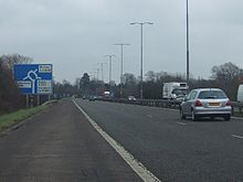
The A308(M) is a motorway in Berkshire, England. It is 0.6 miles (1 km) long.[1] It forms part of the Maidenhead bypass and runs from the M4 at junction 8/9 to the A308 south of Maidenhead town centre.
History
In 1961[2] the A4(M)[3] was opened and ran from the existing junction 7, through a junction with the A308 and ending at a junction with the A4. In 1963 the Slough bypass was opened[2] to junction 7 and the A4(M) was renumbered M4, junction 8 being with the A308 and junction 9 with the A4.
The proposed route of the M4 was then changed to go south of Reading, instead of north of it.[4] When the M4 was extended in 1971,[2] a new junction was provided to connect with what would become a spur. This new interchange was built too close to the original junction 8, so this had to be closed. A new junction (numbered 8/9 so as not to confuse motorists) was built. The original M4 north of this was renumbered as the A423(M) and in the 1990s this was again reclassified as the A404(M). A new spur, the A308(M), was built to maintain access to the A308 and connected with the A404(M) and the M4 at the same grade separated roundabout.
Junctions
| A308(M) motorway | ||
| Eastbound exits | Junction | Westbound exits |
| Road continues as A308 to Maidenhead, Windsor A330 to Ascot and Bracknell (A3095) | A308 & A330 Terminus | London, Reading (M4) A308(M), Oxford A404(M) |
| Maidenhead, Windsor A308, Ascot A330, Bracknell A3095 | Start of motorway | |
| Start of motorway Maidenhead (Central) A308(M) | M4 J8/9 A404(M) | The West M4(W), London M4(E) High Wycombe A404(M) |
Information above gathered from Advanced Direction Signs April 2011
See also
References
External links
.svg.gif)
